Recording, conserving and promoting the landscape and rocks of the Sheffield region
Westphalian Stage
The strata described here are called the Pennine Coal Measures Group and were deposited during a geological time called the Westphalian Stage. In total this spanned about 10 million years of time, between 315 and 305 million years ago. Younger rocks deposited during the final 15 million years of the Carboniferous Period, called the Stephanian Stage, were either not deposited in our area, or were eroded away before the Permian rocks were deposited on top. Rocks from the Coal Measures Group have been valuable economically for coal, clay ironstone, pottery and brick clays and building stone. These strata have also been important hydrocarbon source rocks in the southern North Sea.
Distribution
On a global scale these rocks were formed in an elongated series of paralic (sea level) coal-forming basins more than 100 km wide and stretching over 1500 km across "Euramerica", the name given to the area before the Atlantic Ocean opened up. These basins sagged enough to allow almost 3 km thickness of sediment to be deposited in places, although much less remains today after erosion. During the Westphalian, the belt of inter-linked coal-forming basins stretched along the edge of a large older continent to the north with an ocean to the south. By the end of the Carboniferous, this ocean had closed and the Variscides orogenic belt (fold mountains) were forming (Fig. 1.) Today the deposits are found from the eastern United States, across Ireland (where they have now been mostly eroded away) parts of England and Wales, Belgium, North Germany, Poland and into Ukraine. Earth movements have tilted, uplifted and folded them thereby exposing them to erosion, leaving deposits only in down-folded and faulted basins, often referred to as coalfields. In our area these rocks are found outcropping between the older Namurian "Millstone Grit" rocks and the overlying, younger Permian rocks to the east.
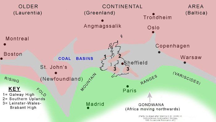
Fig. 1: Late Carboniferous map of "Euramerica" showing the belt of Coal Basins with the Atlantic Ocean closed and present day cities and British Isles coastline overlaid. (Coal Basins re-drawn from Glennie 2000)
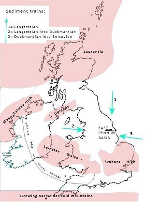
Fig. 2: Generalised map of Westphalian palaeogeography for the British Isles. (Compiled from several sources, but mainly Hallsworth & Chisholm 2000.)
Global and Tectonic setting
Glacial deposits, found in Australia, South Africa and South America indicate that an Ice Age was established in the southern hemisphere at this time. As the ice sheets grew or melted they affected the global sea level, causing coastal advance, or coastal flooding. Our area lay across the Equator and Tropics with evidence in the rocks of very rainy tropical climates and the very large rivers they produce, like the Amazon and Congo today. The record in the rocks demonstrates that continental areas were not in the same position as they are today. Greenland, Canada and the USA were much closer to the west, because the Atlantic Ocean had not yet opened up. The south of France and Africa were a little further away across an ocean to the south, but getting closer to the British Isles throughout the Carboniferous Period. As they collided with the continental mass to the north they closed the ocean and caused the uplift of the Variscides, a large fold mountain belt running from southern Ireland, and Cornwall, eastwards into Poland. This movement caused rocks to be folded and faulted; it uplifted the surface and changed the direction of flow of large river systems; it changed the climate and eventually halted deposition in the coal basins. It destroyed forever the remarkable arborescent lycopsid ecosystem and the largest paralic coal forming environment ever known in the history of Earth. (Fig. 2)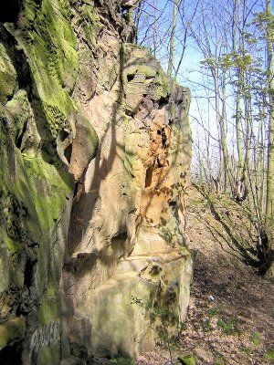
Fig. 3 Channel facies in Mexborough Rock
(Rock face 10 m high)
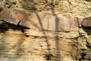
Fig. 4 Silty lake deposits above and below a crevasse splay sandstone in Woolley Edge Rock.
(View 1 m high)
Sedimentology
The Westphalian is divided up into four regional substages. From oldest to youngest these are Langsettian, Duckmantian, Bolsovian, and Westphalian D. In our area no rocks of Westphalian D remain, nor any from the overlying Stephanian. During the early part of the Westphalian the coal basins were frequently flooded by the sea. These muddy beds are called marine bands, and are recognised by the marine fossils they contain. Some can be matched across the whole area of the coal basin chain of Euramerica. This suggests a global rise in sea level, probably caused by melting ice sheets in the southern hemisphere. Later these sea level rises became rare, as tectonic activity caused uplift and tilting during the formation of the Variscides mountain chain to the south.This succession of clastic rocks in the East Pennine basin records deposition by large rivers flowing through a series of basins along a coastal plain between elongate hilly areas of the Southern Uplands and the Leinster-Wales-Brabant High. The rivers flowed between levees across wide floodplains covered by many lakes. The sandstone bodies are thickest where the coarser channel deposits built up (Fig. 3) and thinner where they were deposited during floods on the floodplain. Many channels maintained their position for long periods of time, building a thick, stacked sequence of sediments into sand bodies exceeding 100 m in thickness, with a complex internal structure.
Many silty lake deposits have sandstone layers which formed when the main channel broke through levees during flood, a process called "crevasse splay", which carried a sand layer into quieter waters where finer sediments were being deposited.The mud carried by these rivers was deposited in the still waters of deeper lakes. This means that individual beds thicken up or thin out to nothing across our area, making it very difficult to trace individual beds more than 30 or so kilometres.
Apart from the clastic load of these large rivers, there are beds deposited by organic processes. Across these basins were large areas of swamps and mires, kept wet by the high water table. They allowed large areas of tree-like lycopsid vegetation to grow, and provide fallen organic debris. (Fig 5) Cellulose-digesting bacteria had not evolved at this time, and so the plant material accumulated as peat in the stagnant waters, eventually forming coal seams. Up to 70% of the biomass in the Euramerican Westphalian coal swamps was provided by arborescent lycopsid members of Lepidodendrales, but only 5% in the Stephanian, indicating large changes in vegetation by the end of the Carboniferous. Most arborecent lycopsids became extinct by the Permian, and were replaced by tree ferns. The reason seems to be orogenic destruction of habitat, but climate change may have played a part. Whatever the reason, coal seams, although forming less than 2% of the successions, became extremely important as a fuel source. Common fossils from these rocks are the axes (stems) of plants, called Lepidodendron usually found as flattened impressions, or as interior, or exterior, casts in sandstones. The term "Lepidodendron" was originally used for a variety of preservation styles of stems and defined mainly on leaf cushion and external morphology, but these fossils have now been classified into five separate species.
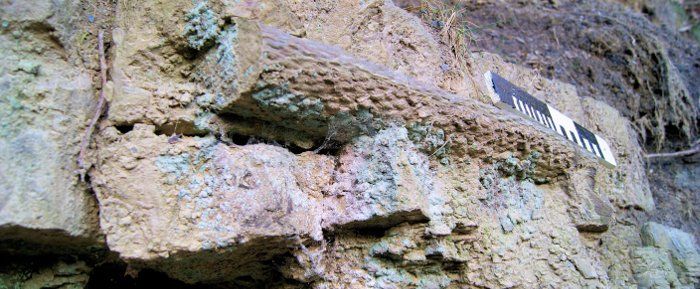
Fig. 5 Internal cast of Lepidodendron axis, Greenmoor Rock (Scale = 0.5 m)
Beneath many of the coals are fossil soil horizons, often with rootlets. Depending on their precise history, the chemical properties of these layers varied: some sandy beds became ganisters; some clay beds, uplifted and exposed to the atmosphere, weathered to kaolin type clays and became "pot clays". Not all coal seams have a fossil soil horizon below them.
In addition to the coarser clastic load, these rivers brought into the paralic coal swamps large amounts of iron, probably in colloidal suspension as hydroxides in close association with clay minerals or organic debris. Where changes in Eh and pH created the right kinds of reducing conditions in the sediment, and in the absence of sulphate ions, anaerobic bacteria caused the precipitation of siderite (FeCO3) forming nodules and bands, often around an organic nucleus. This would happen in the organic rich reducing lake and swamp sediments of the coal-forming environment on the floodplain. Where these conditions persisted they built up an economically useful iron-rich layer called clay ironstone. Examples in the area are the Claywood and Tankersley Ironstones.
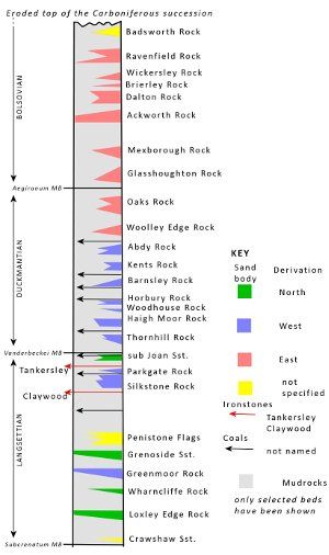
Fig. 6 Generalised stratigraphical column for the Westphalian in the East Pennine Basin showing selected horizons (Contains BGS data Crown copyright and database rights 2012)
Stratigraphy
The stratigraphy arising from this deposition of sediments is not simple. Various features of the sediments themselves and the environment of deposition have complicated the situation. The Westphalian succession is one of muddy beds with sandstone bodies that change thickness, and patchy layers of ironstones, and coal seams which often split due to uneven subsidence of the basin. An additional impediment to understanding arises from the miner's practice of giving local names to the same coal seam, or sandstone, in different areas. Correlating beds across the area was possible because of the marine bands and the bivalve zones that were set up during the last century. (Fig. 6)The base of the Langsettian is defined as the base of the Subcrenatum (Pot Clay) Marine Band and is followed by a series of shales and sandstones with a few coals. The base of the Duckmantian is defined by the Vanderbeckei (Clay Cross) Marine Band. Most of the important ironstones and worked coals are found from the middle of the Langsettian to the middle of the Duckmantian. The base of the Bolsovian is at the Aegiranum (Mansfield) Marine Band, and in our area about 350 m of mudrocks, with relatively fewer coals, extend to the eroded top of the Westphalian succession. In Staffordshire sediments from the younger Westphalian D are found. These are red beds, indicating drier soils and oxidising conditions, and implying uplift, and similar reddening in Westphalian C sediments also occurs near Rotherham.
Detailed work (Hallsworth & Chisholm, 2000) on the lowest sandstones indicate they were brought in from the north, like the underlying Namurian sandstones they resemble (Fig 2). Their heavy mineral content show that in the catchments to these rivers were granites and granulite metasediments suggesting the older roots of the earlier Caledonian orogenic belt were being eroded.
About 200 m up from the base of the Westphalian a series of sandstones derived from the west overlaps the northerly series and continues from the Greenmoor sandstone up to the Abdy Rock. These river catchments produced a heavy mineral suite which suggested that mature sediments, with occasional ophiolite (ancient seafloor, obducted by plate movements) were being weathered to supply the sediment. The source of these rivers is probably along the Variscan mountain front, well into Laurentia.
The Woolley Edge Rock is probably the first of a series of sandstones that continue well into the Bolsovian, where the heavy mineral content suggests the sediment source was along the rising front of the Variscan orogenic belt to the east. The heavy minerals contained in these sandstones suggest a wide variety of orogenic-belt rock types including both low and high grade meta-sediments, granites and ophiolites were being weathered in the catchments.
References
- BGS 1:50,000 Scale Geology Series Map Sheets 87 (Barnsley) and 100 (Sheffield).
- Glennie K.W., in Collinson J. Evans D. Holliday D. & Jones N. (2000) Carboniferous Hydrocarbon Geology; The southern North Sea and Surrounding onshore areas. Yorkshire Geological Society Occasional Publication#7.
- Hallsworth C.R. & Chisholm J.I. (2000) Stratigraphic evolution of provenance characteristics in Westphalian sandstones of the Yorkshire Coalfield. Proceedings of the Yorkshire Geological Society, v. 53, pp 43 -72.
- Taylor T., Taylor E.L., & Krings M. (2009). Palaeobotany: The biology and evolution of fossil plants. Academic Press
