Recording, conserving and promoting the landscape and rocks of the Sheffield region
Permian Period
Permian Geology on the East England Shelf
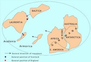
Fig. 1: Composite cartoon showing selected continental area involved in the assembly of Pangea
Introduction
The end of the Carboniferous saw great changes. Permian sedimentation across NW Europe took place in a series of faulted basins and sags, on a huge continental area, only occasionally flooded by shallow continental seas. This continental mass has the name Pangea, and the northwest European part of it was just north of the Equator, with an arid continental interior climate. Pangea was assembled by a series of collisions with micro-continental plates on the southern edge of Laurentia (Fig 1).By the late Carboniferous the large landmass of Gondwana itself collided with these amalgamated and uplifted pieces of crust to form Pangea, a landmass containing most of the significant continental areas of the time. This uplift destroyed the Carboniferous paralic coal swamp environment which had provided a huge carbon sink for planet Earth, resulting in an increase in atmospheric carbon dioxide and an atmospheric warming through the Permian and Triassic Periods, coinciding with the end of the glacial period in the southern hemisphere.
The rocks of this area were subjected to a considerable period of uplift and erosion under arid conditions. Only in the mid Triassic did the Atlantic rifting begin and Canada, America and Greenland, move westwards towards their present positions.
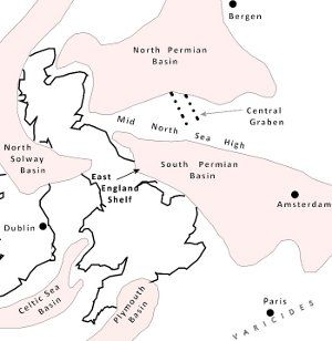
Fig 2: Sketch map showing the distribution of the main Permian basins of deposition around the British Isles
Distribution
The Permian deposits in our area are mainly Upper Permian in age, and now outcrop in a narrow belt running down the eastern side of the country (Fig 2.) They were deposited in an embayment on the western edge of the Zechstein marine basin of deposition, called the East England Shelf. The deposits extended east below the North Sea, into Germany and Poland. They lie on top of a large unconformity (a gap in the rock record) where rocks from the Carboniferous (Westphalian C and D, and Stephanian), as well as most of the Permian Period were either never deposited, or have been eroded away. (See Fig 6). Younger Permian rocks extend eastwards, out of our area, below the coast and under the North Sea basin where they are important components of the oil and gas fields, buried below younger rocks.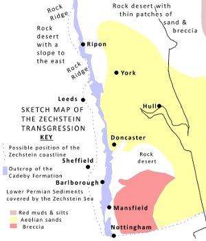
Fig. 3: Sketch map showing Permian sediment types covered by the Zechstein transgression (Re drawn including information from Smith 1968, 1974)
Global and Tectonic Setting
Over about 100 million years during the Palaeozoic, the assembly of Pangea resembled a slow motion motorway pile-up. In southern high latitudes a previous huge continent, called Gondwana, was rifting off small slices and lumps of crust from its northern edge. Several of these pieces were being moved northwards on tectonic plates to collide with a quite large continent called Laurentia (Canada, America and Greenland) positioned across the equator.
In the Devonian period, Baltica collided from the east, forming a larger continent, called Laurussia, followed by a small slice, called Avalonia, colliding from the south (Fig.1.) These collisions resulted in the Caledonian fold mountain range being formed across eastern America, Scotland and Norway and the geological unification of the British Isles area by plate collision. Scotland and Northern Ireland were part of Laurentia, whilst north-west Europe, England, Wales, Southern Ireland, plus a slice of Newfoundland and Nova Scotia were part of Avalonia, itself a rifted piece of Gondwana. It was on the southern edge of Laurussia that the Carboniferous coal swamps formed next to the ocean to the south.
Towards the end of the Carboniferous another slice of Gondwana, called Armorica (mainly NW France and Germany) collided from the south, to be followed by other bits and pieces and then the main mass of Gondwana, raising the Variscides mountains. The only traces of the ocean floor that were once between these pieces are now in the rocks along the joins between them.
Prior to the final impact the crustal area now the British Isles was aligned nearly NW to SE, but, in addition to a northwards drift, the impact also began a clockwise rotation that moved it into its present, more North to South alignment. Our area had become part of a rock desert, with an upland area almost where the Pennines are now. To the east was a rock slope, with ridges, running down to a desert basin, which had breccias forming along the edges, dunes further into the basin and red muds in the centre, where any stream flow formed temporary salina lakes with red muds and salts (Fig 3.) Flash floods flowing into desert basins are known today and in other parts of England, rare plant fragments, plus amphibian and reptile bones and footprints are evidence that conditions were not completely dry.
Sedimentology
Quarrying of these dolomitic limestones for aggregate, building stone and the chemical industry went on in many places in our area, and the quarries, many now not in use, provide many of our exposures (See the Building Stones page). In other parts of the British Isles, unfossiliferous red-beds of the Late Carboniferous pass up into thin unfossiliferous red-bed deposits, mainly breccias and temporary saline lake deposits, making the lowest Permian bed very hard to define. Likewise, a similar transition at the top of the Permian into the Triassic red beds, makes the topmost Permian layer hard to identify. This also means that the evidence for the end of Permian mass extinction, the largest extinction ever to affect life on Earth, is not found in the NW European rock record.
In our area for almost 50 million years this was an area of erosion (See Fig. 6) with little deposition, but by around 256 million years ago dune ridges had formed along the edge of a large shallow desert depression which had saline lakes towards the centre and rocky uplands to the west. These dunes now form the lowest beds in our area, called the Yellow Sand formations, and crop out in patches at the edge of the overlying outcrop of carbonate beds (previously called Lower Magnesian Limestone, but now referred to as dolostone, or dolomitic limestone). When sea level rose, perhaps due to the melting of ice sheets in the southern hemisphere, it flooded the desert basin and formed the Zechstein continental sea with a shallow shelf on its western edge. The sediments on this shelf were sometimes flooded, and sometimes left exposed to weathering, whilst deposition was continuous in the centre. The furthest westwards extent of the coastline was to where Leeds and Sheffield are today.
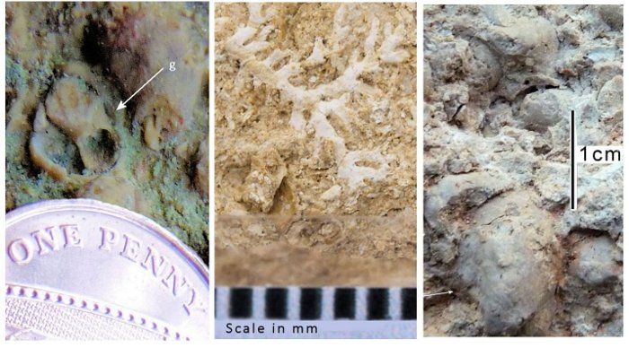
Fig. 4: Fossils from the Permian dolomitic limestones: left, gastropod; middle, bryozoan; right, bivalve
It is possible that the ocean inflow penetrated the desert through the Central Graben in the North Sea High (See Fig. 2) This flooding did not disturb the loosely cemented Yellow Sands, or erode them away, and is thought to have been a quick, but calm, marine transgression, followed from time to time by further inflows of normal sea water. Evaporation and periodic inflows of sea water caused the salinity and water level of the Zechstein Sea to fluctuate, causing several cycles of deposition, which are preserved more fully to the east, where the basin was deeper. The lowest cycles can be seen in our area, but they lack the topmost, very soluble, anhydrite and halite beds, probably because they were dissolved when the area was flooded again.
The first marine beds to be deposited are not found in our area. The Marl Slate - not really a marl and not a slate! - is found in boreholes to the east, filling up the submerged depressions between the dunes preserving fossils of fish, bivalves and plant fragments. This suggests deposition in a healthy marine environment, not far from a land area where some plants were growing. On top of it formed the dolostones showing cross bedding and oolitic structures, indicating increasing salinity, currents and wave action.
Evaporation of this shallow desert sea caused the deposition of limestones, which were later partly altered from calcite to dolomite, (Mg CO3CaCO3) as magnesium enriched saline waters from the main evaporating basin percolated through the porous sediments. On top, evaporate beds of anhydrite and halite (Zechstein is German for "food stone") were deposited, indicating extreme evaporation and salinity. The water became too saline for most life forms to survive and many of the beds are almost unfossiliferous. However, many dolostones have gastropods and beds with numerous bivalves, now poorly preserved with their shells dissolved away, indicating that originally the sea was of more normal salinity, supporting marine life (Fig. 4.)
Evaporation caused a lowering of sea level and an increase in salinity, preventing colonisation by all but the most salt-tolerant of organic life. Along the coastal waters of the East England Shelf cushion reefs developed consisting of bryozoans and sediment anchored by layers of cyano bacteria, called stromatolites. (Fig. 5.) These only survived because the gastropods that grazed on them could not survive in the salty water. The overlying dolostones, are often draped over the reefs (See Fig. 5.) Many of the surrounding beds are often oolitic, indicating wave action in shallow water.
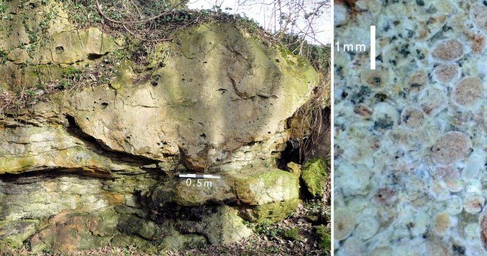
Fig. 5: Stromatolite reef knoll in Cadeby Formation (left) and oolites in dolomitic limestone (right)
Exposure of the sea floor to form a coastal flat above high tide mark extending for a few tens of kilometres along the outcrop is indicated, on at least one occasion, by thin dolostones and very thin green shaley mudstones. These have been called the Hampole Beds and can be found from Ripon in the north to Mansfield in the south. East, towards the middle of the basin, thicker, often evaporite, beds would continue to be deposited. (Smith, 1968).
An influx of ocean water resulted in resumed deposition of dolostone, and when sea currents developed, large cross beds would form, indicating deposition in large ripples, called sand waves. When sea level fell red-brown mudstones containing gypsum (hydrated calcium sulphate) formed by evaporation along the edge of the sea. The uppermost beds in our area are thinly bedded dolostones with wave ripple marks and a few small bivalves, indicating a return to shallow marine conditions in a fluctuating continental sea.
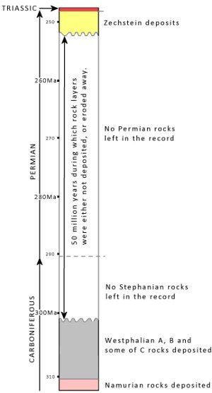
Fig. 6: The basal Permian unconformity
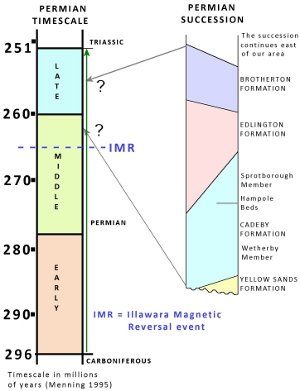
Fig. 7: Sketch geological column showing the stratigraphy of the Permian rocks in the SAGT area
It is not too difficult to establish the lowest Permian beds on the East England Shelf: they lie unconformably on top of the tilted and faulted Carboniferous rocks, in some places starting with the Yellow Sands Formation, which varies in thickness in our area from 4m to nothing, and is poorly cemented, containing rounded grains and large scale cross beds, both indicating aeolian deposition. Borehole information from below the Vale of York suggests dune ridges about 3km wide and 10km long, aligned by the wind in a NE to SW direction. It is, however, difficult to date the onset of deposition because of the paucity of fossils and the diachronous nature of the layers.
Above is the 40m thick Cadeby Formation of dolomitic limestones and dolostones (previously called the Lower Magnesian Limestone), which thins out over the rock ridges near Knaresborough and Catterick. Where the Hampole Beds can be recognised as indicating a temporary retreat of the sea, these carbonates can be divided into the Lower Wetherby Member, which has many bryozoan and stromatolite patch reefs, from the upper Sprotborough Member which has 18m high dune sets indicating marine currents were moving oolite grains into large sand banks, just offshore.
The next layer deposited was of brown mudstones, containing gypsum, indicating it was formed at the edge of the sea where this mineral was not re-dissolved (Fig.7.) This is the Edlington Formation (previously called the Middle Permian Marl), and is itself overlain by the dolomitic limestones of the Brotherton Formation (previously the Upper Magnesian Limestone). These layers reflect a marine retreat followed by another marine influx into the Zechstein Basin. All of these beds indicate deposition, either in a very shallow sea, or at its edges. Later Permian beds do not outcrop in our area. These are the ones containing valuable evaporite deposits, mined further east.
The real problem is establishing the age of these beds so they can be placed in the correct point of the area's geological history, and correlated with exposures and events elsewhere. Often rocks contain some kind of time signal which can be recognised in many places, allowing them to be correlated as the same age, and allow geological time divisions to be established. With these beds, those signals are hard to find. Even the tops and bases of these beds are probably diachronous (not of the same age in all places). Even the cycles of evaporites are only partially useful within the Zechstein, and not elsewhere, even in other basins of the UK.
Traditionally, evolutionary changes in the fossils contained in sedimentary rocks are used to correlate outcrops, but these beds are often unfossiliferous. Other signals that indicate a specific point in time can be: radiometric dating of certain igneous rocks; global sea level rise, producing a widespread transgression; regionally, the presence of a distinctive layer, for example a volcanic ash, which might also be radiometrically dated; geomagnetic reversals, imprinted in certain rocks when the Earth's magnetic polarity switches over; an &"Iridium spike" caused by the impact of a certain kind of meteorite. For forty years the debate about which geological sections, and which events could be used to divide the Permian period of time has continued. The diagram (Fig. 7) uses Menning's 1995 timescale and the threefold division of the Permian. Apart from the International stage names, which draw heavily on Chinese sections, different systems have been used in Germany, North America and Russia.
The most useful event seems to be the Illawara geomagnetic reversal event, which ended a 50 million year long period of reversed geomagnetic polarity (compass points south). This event is dated (elsewhere) at around 265 million years. The red beds in the Permian contain many tiny grains of iron oxide (Fe2O3) and have a strong remnant normal magnetisation (compass points north) from the time they were deposited. Since these beds record normal polarity geomagnetism they are presumed to be younger than the reversal event at 265 million years. This means they are, probably, mainly Late Permian in age (See Fig. 7.)
References
- BGS 1:50,000 Geology Series sheets 87 and 100.
- BGS 2002 The Pennines and adjacent areas (Fourth edition).
- D.B. Smith (1968) The Hampole Beds - a significant marker in the Lower Magnesian Limestone of Yorkshire, Derbyshire and Nottinghamshire. Proceedings of the Yorkshire Geological Society, Vol. 36, Part 4, pp 436-477.
- D.B. Smith (1974) Permian, in, The Geology and Mineral Resources of Yorkshire. Eds D.H. Rayner & J.E. Hemmingway. Yorkshire Geological Society.
