Recording, conserving and promoting the landscape and rocks of the Sheffield region
Local Geological Sites (LGS or RIGS) in South Yorkshire
Since the 1970s, there has been an intermittent history of surveying and recording of interesting and important geological features in the Sheffield area, driven by a series of Government or national initiatives and guidelines. The most recent of these documents is the Geodiversity Charter for England, published in 2015 by the English Geodiversity Forum (http://www.northern-england-geology.co.uk/geodiversity-charter-for-england.pdf). All of this local survey work has been undertaken by voluntary or part-funded groups of geoscientists. During this time, responsibility for recording, monitoring and conserving these sites has passed from group to successor group and is currently being undertaken by the Sheffield Area Geology Trust (SAGT).
In 1990 English Nature (now Natural England) introduced a scheme to identify Local Geological Sites (LGS) that have both interest and value but were not specifically designated as Sites of Special Scientific Interest (SSSIs). The objective was to create a record of such sites which, although not protected by legislation, could still be taken into consideration when evaluating development proposals as part of the planning system. In 1996, a team known as the South Yorkshire RIGS Group received funding to undertake a survey for such sites in three of the four Local Authority areas in South Yorkshire. The outcome of this work was the designation of 80 Regionally Important Geological Sites (RIGS). The acronym ‘RIGS’ has since been superseded by ‘LGS’, although both terms are in common use and are equivalent to each other.
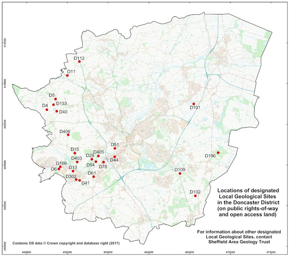
Of the 80 original LGS in South Yorkshire, 26 were located in the Sheffield City area, 19 in the Sheffield part of the Peak District National Park, 23 in Rotherham district and 12 in Barnsley district. A similar survey was undertaken by the same team in the Doncaster district in 1997, which added a further 27 sites, bringing the total to 107. Since that time a small number of LGS have been destroyed by urban development or lost through neglect, but a larger number of new sites have been designated to replace them and also to increase the range and variety of geological features that can be seen.
The geology of South Yorkshire is comprised of a succession of layered sedimentary rocks of Mid to Upper Carboniferous and also Upper Permian ages. The selection of the original set of South Yorkshire LGS was intended to identify and conserve as many outcrop examples of named individual stratigraphic layers as possible. Other features of geological interest, such as geomorphological features, faults, caves, mineral extraction sites and modern fluvial processes etc., were also included.
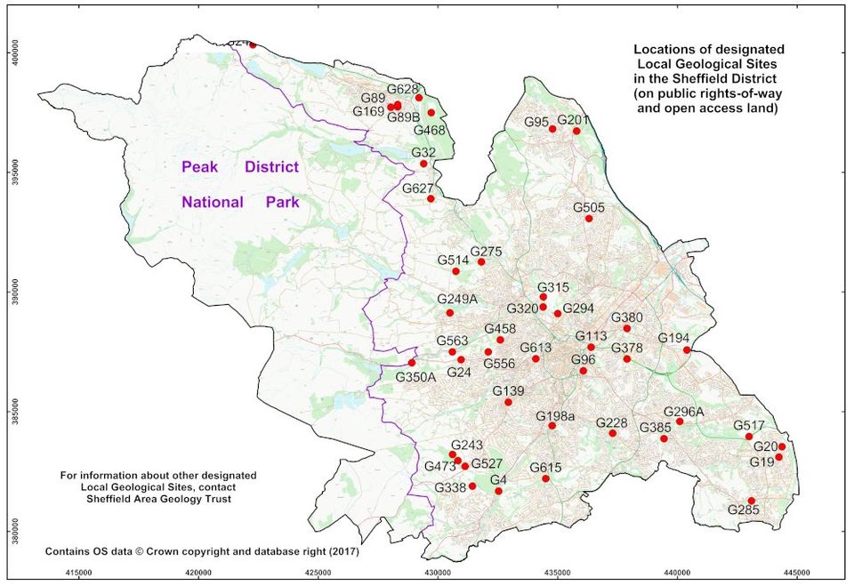
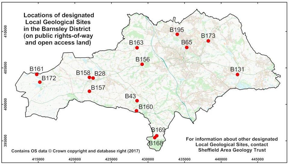
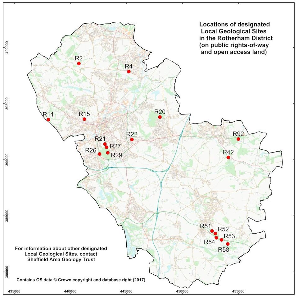
At the present time, there are 48 designated LGS in the Sheffield City area, 19 in the Sheffield part of the Peak District National Park, 31 in Barnsley district, 26 in Rotherham district and 26 in Doncaster district. Many of these sites are located next to public footpaths or on open-access land, although some are inevitably located on private property. Lists of the publicly-accessible LGS in each of the four Local Authority areas are tabulated below, accompanied by maps showing their general locations.
Sheffield LGS with public access
| Site ID | Site name | Principal interest |
|---|---|---|
| G4 | Abbeydale - Ladyspring Wood | Woodhouse Rock |
| G19 | Beighton -1 | Cyclothem above the Norton Coal |
| G20 | Beighton -2 | Woodhouse Rock |
| G24 | Bell Hagg Quarry | Chatsworth Grit |
| G32 | Bitholmes Lead Mine | Chatsworth Grit |
| G89 | Carr Head (Deepcar) | Strata above Middle Band Coal |
| G89B | Carr Head - 2 (Deepcar) | Strata above Middle Band Coal |
| G95 | Charlton Brook -3 | Strata above Whinmoor Coal |
| G96 | Cholera Monument | Silkstone Rock |
| G113 | Cricket Inn Road railway cutting | Parkgate Rock |
| G139 | Ecclesall Road Quarry, Marriot Road | Greenmoor Rock |
| G169 | The Glen [Stocksbridge] | Crawshaw Sandstone |
| G194 | Handsworth Railway Cutting | Handsworth Rock |
| G198a | Heeley Retail Park | Greenmoor Rock |
| G201 | Hesley Park | Strata above Thorncliffe Coal |
| G228 | Hurlfield quarry | Strata below Whinmoor Coal |
| G243 | Limb Valley | Strata above Ringinglow Coal |
| G248 | Little Don Stream Section (SSSI) | Strata associated with Pot Clay Coal |
| G249A | Little Matlock 3 /Acorn Hill (Stannington Ruffs SSSI) | Crawshaw Sandstone |
| G275 | Wadsley Fossil Forest | Strata beneath Middle Band Coal |
| G285 | Knowle Hill Storage Depot, Mosborough | Deep Hard Rock |
| G294 | Neepsend Brickpit (SSSI) | Strata below Greenmoor Rock |
| G296A | Normanton Spring A | Deep Hard Rock |
| G315 | Parkwood Springs railway cutting (SSSI) | Strata between Hard Bed and Norton Coals |
| G320 | Parkwood Road railway bridge cutting (SSSI) | Strata between Crawshaw Sandstone & Norton Coal |
| G338 | Ran Wood - 2 | Strata associated with the Ganister Coal |
| G350A | Rivelin Mill Bridge West | Heyden Rock |
| G378 | Sheffield Parkway - 2 | Strata beneath Clay Cross Marine Band |
| G380 | Sheffield and Tinsley Canal | Strata associated with the Dunsil Coal |
| Sheffield sites continued | ||
|---|---|---|
| G385 | Shirebrook (Frecheville) | Strata associated with the Thorncliffe Thin Coal |
| G458 | Walkley Bank (The Bole Hill) | Crawshaw Sandstone |
| G468 | Wharncliffe Crags (SSSI) | Wharncliffe Rock |
| G473 | Whirlowdale Park | Redmires Flags |
| G505 | Hartley Brook Dike | Strata above the Penistone Flags |
| G514 | Loxley Edge | Loxley Edge Rock |
| G517 | Mosborough Parkway | Woodhouse Rock |
| G527 | Whinfell Quarry Gardens | Rough Rock |
| G556 | Marsh Lane Quarry, Crosspool | Redmires Flags |
| G563 | Samehill Farm (Bell Hagg) | Strata between Heyden Rock and Chatsworth Grit |
| G613 | Octagon Centre (near), Sheffield | Grenoside Sandstone |
| G615 | Meadow Head quarry | Greenmoor Rock |
| G627 | Delf Hill Quarry | Rough Rock |
| G628 | Don River Bridge Quarry, Deepcar | Loxley Edge Rock |
| G629 | Tinsley golf course | Historic workings on Wathwood Coal |
| G630 | Graves Park ravine | Greenmoor Rock |
Barnsley LGS with public access
| Site ID | Site name | Principal interest |
|---|---|---|
| B28 | Westfield Lane Quarry | Grenoside Rock (cross-bedded sandstone) |
| B43 | Thurgoland Tunnel Cutting | Grenoside Rock and overlying mudstones |
| B65 | Burton Bank Quarry | Woolley Edge Rock (cross-bedded sandstone) |
| B131 | Quarry Hills Railway Cutting | Mexborough Rock (cross-bedded sandstone) |
| B156 | Silkstone Bypass | Silkstone Rock and overlying mudstones |
| B157 | Hartcliff Hill | Greenmoor Rock (cross-bedded sandstone) |
| B158 | Thurlstone Bank | Grenoside Rock and underlying mudstone |
| B160 | Green Moor Delph | Greenmoor Rock (cross-bedded sandstone) |
| B161 | Harden Clough | Rough Rock, with Rough Rock Flags and underlying mudstones |
| B163 | Cawthorne Bypass | Parkgate Rock and Cawthorne Fault |
| B168 | Hobbs Stones Tors | Periglacial landscape from eroded Loxley Edge Rock |
| B169 | Scarp in Wharncliffe Rock | Scarp-and vale landscape feature, formed from Wharncliffe Rock |
| B172 | Winscar Reservoir | Huddersfield White Rock, with underlying mudstones |
| B173 | Station Road Quarry, Cudworth | Glasshoughton Rock (cross-bedded sandstone) |
| B195 | Staincross Cutting | Oaks Rock and Anglian drift |
Rotherham LGS with public access
| Site ID | Site name | Principal interest |
|---|---|---|
| R2 | Hoober Plantation, Wentworth | Abdy Rock |
| R4 | Hermit Hill Quarry, Swinton | Oaks Rock |
| R11 | Thundercliffe Grange Quarry | |
| R15 | Bradgate Brick Pits | Strata between Clay Cross Marine Band and Lidget Coal |
| R20 | Silverwood Quarry , Ravenfield Common | Ravenfield Rock |
| R21 | Boston Park, Canklow | Mexborough Rock (red facies) |
| R22 | Great Bank | Dalton Rock |
| R26 | Canklow Meadows | Mexborough Rock (red facies) |
| R27 | Canklow Woods | Mexborough Rock (red facies) |
| R29 | Canklow Woods 2 | Mexborough Rock (red facies) |
| R42 | Roche Abbey and Nor Wood Caves | Cadeby Formation |
| R51 | Anston Stones Wood | Cadeby Formation |
| R52 | Anston Stones Wood 2 | Cadeby Formation |
| R53 | Anston Stones Wood 3 | Cadeby Formation |
| R54 | Anston Stones Wood 4 | Cadeby Formation |
| R58 | Lindrick Dale | Cadeby Formation |
| R92 | Maltby Wood Cave (railway cutting) | Cadeby Formation (view from bridge only) |
Doncaster LGS with public access
| Site ID | Site name | Principal interest |
|---|---|---|
| D4 | Watchley Crags | Cadeby Formation |
| D5 | Hooton Pagnell Village Pound | Cadeby Formation |
| D6 | Denaby Lane | Mexborough Rock |
| D11 | Hazel Lane Quarry | Cadeby Formation |
| D13 | North Cliff Quarry | Cadeby Formation |
| D15 | Melton Park | Cadeby Formation |
| D28 | Pot Riding Wood railway cutting | Cadeby Formation |
| D40 | Bilham quarry | Cadeby Formation |
| D41 | Ashfield brickpits | Cadeby Formation |
| D44 | Cedar Road Adventure Playground | Sherwood Sandstone |
| D51 | Hexthorpe Flatts | Brotherton Formation |
| D61 | New Edlington Brick Pit | Edlington Formation |
| D78 | Warmsworth Park | Cadeby Formation |
| D94 | Warmsworth Quarry | Cadeby Formation |
| D101 | Dunsville Quarry | Sherwood Sandstone |
| D102 | Common Lane Quarry | Sherwood Sandstone |
| D109 | Hurst Plantation Quarry | Anglian sand and gravel |
| D112 | Parknook Quarry | Cadeby Formation (Wetherby Member) |
| D133 | Hooton Pagnell | Cadeby Formation (Wetherby Member) |
| D166 | Doncaster Road | Mexborough Rock |
| D190 | Blaxton Common | Sherwood Sandstone |
| D302 | Conisborough Caves South | Cadeby Formation |
| D403 | Cadeby Waste Water Works | Dalton Rock |
| D405 | Levitt Hagg Wood | Cadeby Formation |
| D406 | Barnburgh Cliff | Cadeby Formation (basal contact) |
