Recording, conserving and promoting the landscape and rocks of the Sheffield region
SAGT News Archive 2019
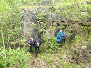
Visit by members of the Open University Geological Society, August 16 2019
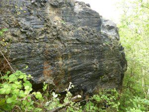
SAGT played host to a visit by eight members of the East Midlands branch of the Open University Geological Society on August 16. The weather was not kind – it rained all day. Nevertheless, the group followed the complete itinerary with enthusiasm. The morning walk included a circuit around Ringinglow, including an inspection of outcrops of the Rough Rock in Brown Edge Quarries, and the erosional remnants (tors) formed from Rivelin Grit called the Ox Stones, situated above Lady Canning’s Plantation. After a fine lunch at the Norfolk Arms (Ringinglow), the party inspected an outcrop of the Swallow Wood Coal at Darnall and then concluded their visit by viewing the side of a narrow cutting excavated through a thick sandstone body called the Woodhouse Rock. The cutting is located near the Drakehouse Retail Park and the upper roundabout on the Mosborough Parkway (A57). It contains the public footpath connecting Hackenthorpe with Beighton. More extensive outcrops of the Woodhouse Rock are visible on both sides of the A57 between the Drakehouse and Woodhouse roundabouts.
Both the Rivelin Grit and the Rough Rock are regional, sheet-like sandstone bodies of upper Namurian age (approx. 314 million years ago). The former is regarded as having been deposited by a large river and delta system which was affected by significant fluctuations in sea level. The rivers carried sediment into the Pennine Basin from a source area in present-day Scandinavia. The Rough Rock has been interpreted as being deposited by a wide, braided river system which also flowed across this region from a northeasterly direction. Outcrops of both of these sandstone units can be followed from the Leeds area in the north to beyond Belper in the south.
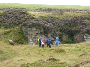
Members of OUGS appreciating Brown Edge Quarries in the rain
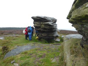
Members of OUGS sheltering behind Ox Stones
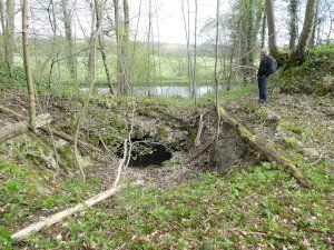
Geophysical surveying near Elsecar, July 31 2019
Two members of SAGT were part of a small team of people involved in a geophysical survey near Elsecar. Its purpose was archaeological, i.e. to investigate whether any buried foundations remain from a long-since demolished colliery pumping engine house in the Jump Valley. The building and its steam engine would have been similar to the surviving example preserved at the Elsecar Heritage Centre. Two instruments were employed – a fluxgate gradiometer, which detects disturbances in the Earth’s magnetic field caused by buried objects with varying iron content, and an Earth-resistance meter, which measures variations in electrical conductivity in the ground.
Unfortunately, the results of the survey did not reveal any obvious patterns that can be interpreted as being associated with buried industrial structures. The random ‘noise’ in the data is likely to be caused by a shallow layer of demolition rubble and the position of a later trench containing a large drain pipe is also evident. The survey had to be abandoned very suddenly, without being completed, when a heavy rain shower caused a nearby drain to overflow, sending a small tsunami of dirty water towards the survey site.
Jump Valley
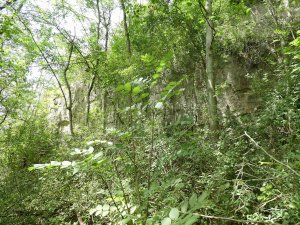
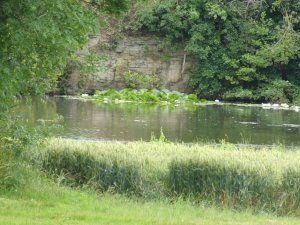
Further investigations into the Cadeby Formation, 10th July 2019
An overgrown face in the Cadeby Formation
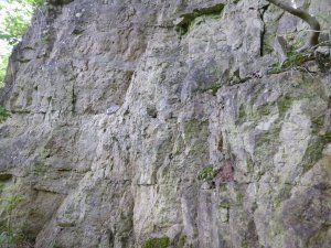
Part of the same face after a little “gardening”
Using a telephoto lens to check on an inaccessible quarry face
SAGT members are continuing to support student Jamie Beadnell of Derby University, by assisting with access to exposures of the Cadeby Formation in the vicinity of the Chesterfield Canal, near Shireoaks. At the same time, we are able to update our own records regarding sites which have not been visited for many years. On 10th July, two privately owned quarries were visited and another was photographed with telephoto lenses from a distance. The owner of one of the sites emphasised the former use of the canal in conveying the output from all the quarries in close proximity to it. Much of this cargo consisted of lime, produced on site, and one of the quarries still has the broken remains of large lime kilns on the floor.
Although the weather is more conducive in the summer than at other seasons, the vegetation is reminiscent of the Burmese jungle and progress was slow. At one site, the vegetation was beaten down, only to reveal a wide lake, with the old quarry face dropping sheer into the water on the other side. In the other quarry, hawthorn bushes on the floor posed a hazard and trees and brambles close to the face made inspection difficult. However, some close up observations were achieved, with a possible channel cutting across planar bedding. The numerous butterflies were a bonus!
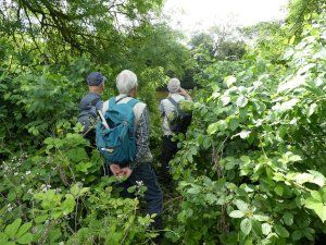
Eat your heart out, Indiana Jones!
Undergraduate Field Project, University of Derby - posted 16 June 2019
On June 14 SAGT members organised an introductory field excursion to the Lindrick Dale and Anston Stones Wood area for Derby University geology student Jamie and his supervisor. Jamie has selected this area for his undergraduate field project, with the aim of investigating local stratigraphic and lithological variations of the Cadeby Formation dolostone (magnesian limestone), of Upper Permian age. Numerous rock outcrops across the area are available for study - forming the sides of natural ravines and exposed in several abandoned historic quarries. There is also some interesting structural geology to be seen, associated with reactivation of the Kiveton Anticline and fault system, which affected the underlying Coal Measures. The latter deformation occurred during the Variscan Orogeny, at the end of the Carboniferous Period. The complicated fold and fault structure was reactivated during the Eo-Alpine Orogeny in the Palaeogene Period (Early Tertiary Sub-Era), producing gentle undulations and faulted displacements in the Cadeby Formation.
The photographs were taken in Wood Mill Quarry.
The first shows the group inspecting an outcrop to identify original sedimentary textures that have survived the recrystallization process which accompanied the alteration of the limestone to dolostone.
The second photograph shows an exposed fault plane, scored by slickensides and partially coated with a thin film of flowstone and tufa-cemented debris.
Wood Mill Quarry 1
Wood Mill Quarry 2
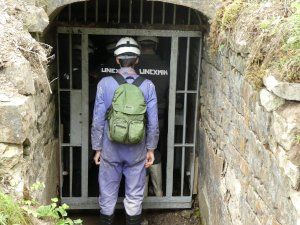
Project at Ecton Mine - posted 31 May 2019
Three members of SAGT assisted with an exciting project, hosted by the Ecton Mine Educational Trust, to explore the flooded levels of Ecton Copper Mine in North Staffs, during May. Most of the mine workings have been flooded since the 1850s, to a water depth of 300 m.
Further details: www.unexmin.eu/news
The UNEXMIN project is a European scheme to develop autonomous robots, carrying an instrument array capable of mapping flooded cavities, taking water samples and testing for minerals present in the walls of the old mine chambers etc. It is still under development but the two robots were successfully deployed to depths of more than 100 m.
The vastness of the worked-out cavities hidden deep beneath Ecton Hill was demonstrated and previously unknown links between the various shafts and ore bodies were discovered. A huge quantity of data was recorded, which will take a while to analyse and publish.
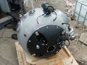
One of the robots closed up and ready to take into the mine for launching
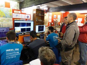
The control room at the Geoff Cox Educational Centre, Ecton Mine
Team taking robot into mine
(on electric wheelbarrow)
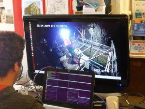
A screen view of the robot about to be launched in to the shaft
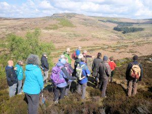
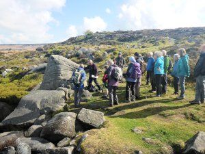
SAGT led excursion to Burbage Edge - 11 May 2019
SAGT geologists led an excursion to the southern end of the Burbage Valley on 11th May as part of Sheffield Environment Weeks, Yorkshire Geology Month and Geoweek 2019. The walk was attended by 16 people with glorious sunshine.
Clambering over blocks of gritstone on the way to the two deep quarries on the eastern edge of the valley revealed a wide range of features, ranging from sedimentary structures and fossil plant imprints, to the marks of human activity.
Marks of quarrying include drill holes for the “plug and feathers” technique of splitting blocks, millstones in various states of preparation, and some amazing lines of chisel marks where workers had optimistically begun to mark out the division of huge masses of gritstone.
Many of the blocks are pock-marked by bullet holes or mortar blasts from WW2 when the valley was used for live-firing training.
The group saw evidence for the evolution of the landscape under periglacial processes and discussed the origins of ironstones in the shales next to the river.
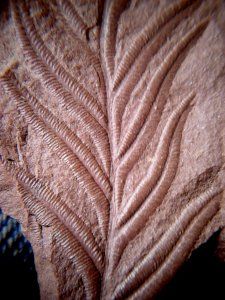
East Pennines Coalfield fossil carried by ice to Norfolk - posted 8 May 2019
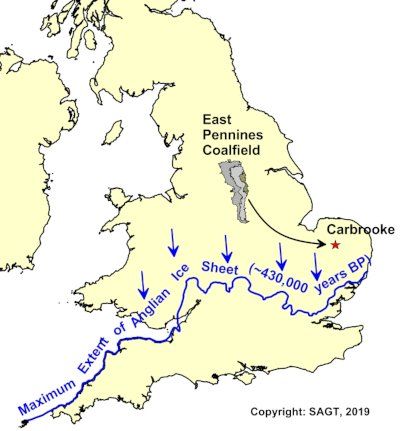
On display in the natural history gallery in Norwich Castle Museum is a fine specimen of a fossil leaf imprint of the
Westphalian-aged plant species Neuropteris gigantea, preserved in a sideritic concretion. This specimen originated from the exposed East Pennines Coalfield. It was eroded by glacial scouring of outcropping Coal Measures strata approximately 430,000 years ago and transported by ice approximately 180 km to the area of Carbrooke village in Norfolk, where it was discovered in a gravel pit.
Postgraduate research at the University of Sheffield - posted 20 April 2019
In April SAGT was able to assist Martha Gibson, a PhD student at Sheffield University (and funded by NERC ACCE DTP) in locating sample sites in the Permian outcrop. Her study will undertake the first modern palaeoecological and palaeoenvironmental analysis of UK Zechstein deposits and adjacent North Sea basin. The Zechstein Sea underwent cycles of isolation and evaporation causing dramatic changes, but the causes of change are unclear. This project will integrate palynological data with macropalaeontological, sedimentological and stratigraphical studies to investigate whether climate change was responsible for the cyclicity of evaporation causing dramatic changes in terrestrial vegetation and marine phytoplankton.
Outcrops along Mosborough Parkway public footpath - visited on 16 April, 2019
SAGT‘s intensive work on the sandstones associated with the Swallow Wood Coal at the Nunnery site near Darnall in 2018 has led to further research into lateral equivalents of the same strata in the Sheffield area. Rock outcrops beside the A57 Mosborough Parkway, and also in a rather more pleasant location in a nearby footpath cutting, expose a more massive-bedded sandstone unit with a contrasting character to the sandstones observed at the Nunnery site. This sandstone body exists at a similar stratigraphic horizon but its origin may be different. SAGT revisited the site on April 16th to make further observations and to take new photographs. Large-scale planar and trough cross-bedding structures can be seen which demonstrate a south-westerly source for the sediment. It was a pleasant Spring day, and in the quiet footpath cutting the intensity of the birdsong caused a distraction from the geology!
Cross-bedding in sandstones - Mosborough Parkway
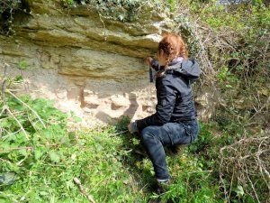
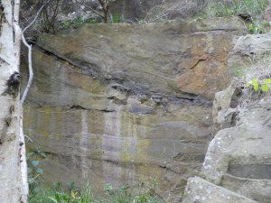
Reconnaissance visit to old quarries along the Chesterfield Canal – 10 April, 2019
In recent years, SAGT has been able to assist undergraduate geologists from Derby University in finding suitable topics for field studies for their final degree dissertations. This summer, a student will be allocated to investigate the dolomitic limestone of the Cadeby Formation in the area around Lindrick Dale and the Chesterfield Canal. Two or three visits have been made to the area, mostly to enable us to update our own records, but also to plan for the Derby work. The latest of these was on 10th April, when quarries alongside the Chesterfield Canal were visited. Although rather badly overgrown, some of the faces are sufficiently clear to be worthy of study. The stone was quarried for many reasons, not the least of these being for making lime, and the remains of several limekilns are still visible, close to the canal, for ease of transport in former times.
Limekiln beside the canal at Hawkswood Quarry,
Thorpe Salvin
Science Week Walks - Saturday 9th March 2019
SAGT members had arranged to lead two walks for the public on Saturday 9th March – a cold rainy day. The first walk in the morning was due to start at the Peace Gardens and proceed by a pedestrianised route to the Cathedral, but.... nobody turned up! So the two leaders amused themselves examining the Jurassic limestone paving in the warm annexe to the Mercure Hotel (with permission) and discovered a puzzling fossil, among the belemnites, ammonites, and rudistids. Can anyone suggest what it is?
They then investigated the new landscaping in Charter Square and in front of the new HSBC building (still fenced off during construction). Most of the sedimentary rocks are from Derbyshire, but the granite paving is from China. We have yet to find out the source of the new granite paving at the lower end of Cambridge Street, but it is crammed with orientated feldspar crystals, presumably indicating flow in the magma.
We fared rather better in the afternoon in the General Cemetery with 5 visitors (but none of the 20 who had booked at the Office!). No matter how many times this tour is repeated, the leaders always learn something new, and the visitors seemed to feel that they had gained a lot from the walk too. At this venue, there was a welcome opportunity to warm up over a cuppa in the recently restored Samuel Worth Chapel and to pore over geological maps and diagrams.
Unidentified fossil in floor of Mercure Hotel
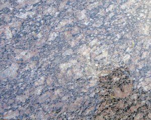
Cambridge Street: Flow-aligned granite
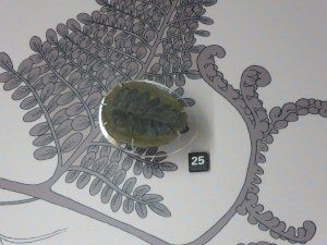
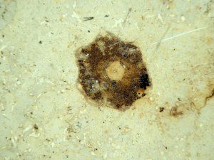
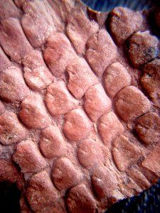
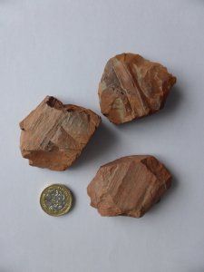
Fossils on a Footpath - February 2019
A very observant correspondent has drawn SAGT's attention to a recently laid, temporary footpath which connects Lescar Road in the new Waverley housing estate to Whitby's Fish and Chip Restaurant on Poplar Way, near to Boundary Mill Stores on the Sheffield Parkway. The loosely-spread, gravelly material forming the surface of the footpath is mostly red in colour and appears to be baked shale. This has probably been screened from a reclaimed colliery waste tip. High temperatures were often generated deep inside colliery tips, caused by combustion of coal dust associated with the oxidation of pyrite. The temperatures were hot enough to bake pieces of broken shale into a harder substance resembling brick. The source of this particular recycled aggregate is not known.
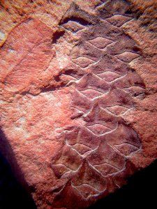
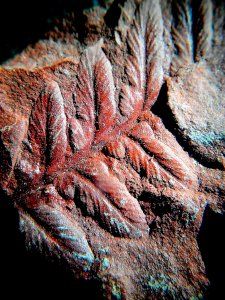
Our correspondent, Eric S., noticed that some pieces of the gravel on the footpath contain fragments of fossilised plants. Some of Eric's photographs are shown below. These specimens are Coal Measures plants, of Upper Carboniferous age, which grew in the swampy conditions that produced the coal seams of the Yorkshire Coalfield. Although any residual carbon in these fossils has been lost during baking, some fine botanical detail has been preserved.
Plant species provisionally identified so far include Cordaites, Neuropteris
and Alethopteris
leaves and fronds, and Sigillaria
and Lepidodenron
pith casts. Other species also seem to be present but are more difficult to identify with certainty.
Many thanks to Eric for sharing this information.
Footpath leading towards the new Waveley estate
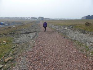
Opportunistic Surveying - 19 January 2019
Our attention has been drawn to a substantial excavation beside Abbeydale Road, Sheffield S7, in preparation for a development in the grounds of the former Gatefield House. Such exposures are temporary, but can often add useful information about the local geology. In this case, there is an existing Local Geological Site, near the junction of nearby Marden Road with Abbeydale Road, so this new exposure enables us to examine rather more of the Greenmoor Rock along the strike of the outcrop, albeit from the public pavement.
Please keep your eyes peeled for other similar opportunities and let us have any observations, measurements and photographs, so that they can be added to the existing database of sites within South Yorkshire. If a site cannot be inspected from public areas, then please ensure that you have permission from the owners to visit the site and be aware that safety clothing and boots will probably be required.
Temporary exposure of Greenmoor Rock, Abbeydale Road
