Dove Valley Section - Trans-Pennine Geology Trail
No matter how you travel along the Trans - Pennine Trail(TPT) on foot, by bike or on horseback, you should keep your eyes open for the ways in which the geology has helped form the land, and the way people have used it over the centuries. You will need to use an Ordnance Survey map to plan your trip properly and the BGS Barnsley BGS map sheet 87 will also help.
Barnsley rocks - Introduction
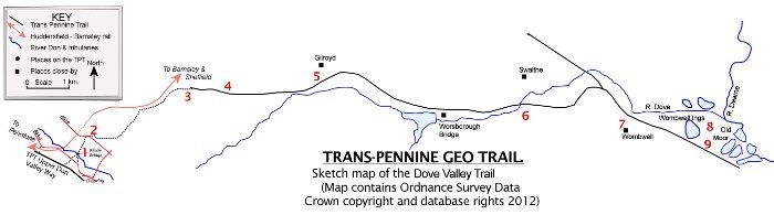
The route runs from the footpath link on the Upper Don Way section of the TPT at SE 265024 to the Dove Valley Trail at Knabbes Hall and then east to Old Moor wetlands east of Wombwell. The first part crosses the River Don at a historical bridging point and then climbs the valley sides to the main watershed in Barnsley. There is a short section along the very busy A629 before following the path eastwards to Wraith House, then more north eastwards to Far Coates and Silkstone Common before reaching the Dove Valley Trail to Old Moor. On the way you will pass through scenery bearing the influence of the underlying Carboniferous rocks and the weathering that has affected them, but it is also a trip through a landscape where the geology has helped shape the hills, the buildings, the people who lived here and the jobs they did.
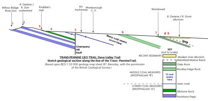
- SE 267026 Willow Bridge: This is the start of the footpath link from the TPT at Penistone to the Dove Valley section of the TPT and can be reached from the B6462 between Penistone and Oxspring. The bridge, built around 1734, is important as one of the crossings on one of the largely forgotten old Salt Roads from the Cheshire Plains to west of the Pennines and the old river ports, like Bawtry, on the river Idle to the east. Salt is a mineral formed from the evaporation of salty water during the Triassic period when Cheshire had a desert climate. Humans have always valued it for food preservation and cooking. After it was mined it was then moved very large distances over land by packhorse. Willow Bridge, like the Unsliven Bridge over the River Little Don, is a river crossing on the old route from Bradfield to Wakefield.
- SE271030 Dearne and Don watershed: The steep valley slope up to the very busy A629 Huddersfield road was cut into the Penistone Flags by the River Don. At the top you are standing on the main watershed in Barnsley between the Don, which flows south to Sheffield, and the Dearne, which flows east to meet the Don just west of Doncaster. On a clear day from the top you can see eastwards to the flat skyline, marking the top of the Permian Limestone, which overlies the Carboniferous rocks forming the intervening ground. Some days you can see the tops of the power stations sited in the Trent valley beyond. The footpath goes a few hundred metres south east along the busy A629 before heading east down the dip slope of the Penistone Flags to the main railway line between Penistone and Barnsley. Then it runs eastwards, to Knabbes Hall and the Dove Valley Trail just south of Silkstone Common.
- SE 291041: the footpath joins the Dove Valley Trail and continues eastwards in the same direction that the rock layers dip, so you are walking onto progressively younger rocks. About 20 m below your feet, as you cross Knabbes Lane, lies the Claywood Ironstone layer, mined in the past for iron and used locally. The mineral is siderite, an iron carbonate, and is not a very pure form of ore. It formed during the Upper Carboniferous, about 311 million years ago in stagnant sediments where there was little oxygen.
- SE306040: At this bridge over the road, SE of Silkstone Common, is a sign board and directions to the Huskar Pit memorial. The memorial to this disaster lies in Nabs Wood just to the south and is worth a visit. In the disaster many young miners lost their lives as the pit was partly flooded during a storm.
- SE323042: Here the TPT crosses the line of the Champany Hill Fault, one of the many faults to affect the coal seams. When it moved it would have created earthquakes (about 290 million years ago) but there is barely any sign at the surface now because the uplifted rocks have weathered away. Half a kilometre further on you cross the motorway and get into an area with thirteen coal seams, although they are not visible at the surface. To the south is Worsborough Reservoir which takes water from the dip slope streams to the west between Dodworth and Hoods Green to the south. In the past such streams would have provided water power for local industries.
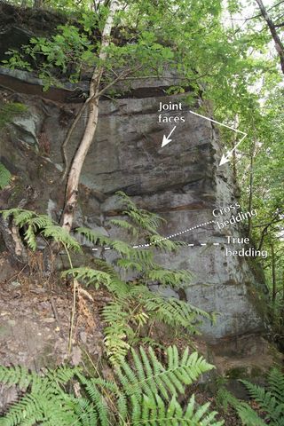
- SE 358036: Just south of Swaithe the River Dove flows through a narrower valley cut into the Woolley Edge Rock, a sandstone that forms an important scarp running through Burton Bank park in Barnsley as far north as Normanton. This sandstone was laid down in a large river channel and floodplain which flowed through tropical tree-fern forests around 310 million years ago. If you look at the rock faces on the right (south) of the trail at SE 375038 you can see the sandstone in right angled joint blocks, with true bedding, which shows the original top of the sediment layer, and angled cross bedding, which are part of the fossilised front faces of giant "ripples" that formed in the river channel. The cross-bedding shows that the Carboniferous river that laid it down was flowing in a southerly direction.
- Wombwell was built on the dip slope of the Oaks Rock sandstone, just above the flooding level of the wetlands to the east.
- East of Wombwell lies Old Moor, a reclaimed area on the alluvium deposited by the Dearne and Dove rivers which meet just east of here. The alluvium is much more recent than the rocks you have walked over, and continues to build up today in the lakes of the Old Moor reserve.
- Buried under the alluvium is the Mansfield Marine Band, a fossiliferous muddy rock which is important as it is taken as the dividing surface between the rocks of the Westphalian B time period (called Duckmantian) and the rocks of the overlying Westphalian C time period (called Bolsovian). This layer is scientifically very important as it represents a flooding of the area by a rise in sea level. It can be traced across Europe to Ukraine and also can be matched in the coalfields of the eastern USA. Barnsley is home to the SSSI (Site of Special Scientific Interest) that preserves this bed for scientists across the world to study.
Woolley Edge Rock sandstone south of Swaithe
N.B.
The inclusion of a site does not imply that there is any right of access. Some site features may be viewed from public roads and paths, but many sites are in private ownership and permissions from the landowner and/or land manager may be needed to visit more closely. Health and Safety risk assessments should be made prior to visiting all sites, to include such hazards as traffic, trip hazards or rock falls. SAGT takes no responsibility for any injury sustained, nor for any infringement of ownership rights, as a result of a site being described on this website.