Recording, conserving and promoting the landscape and rocks of the Sheffield region
Trans-Pennine Geology Trail - Barnsley Section
No matter how you travel along the Trans Pennine Trail (TPT), on foot, by bike, or on horseback, you should keep your eyes open for the ways in which the geology has helped form the land, and the way people have used it over the centuries. You will need to use an Ordnance Survey map to plan your trip properly.
N.B.
The inclusion of a site does not imply that there is any right of access. Some site features may be viewed from public roads and paths, but many sites are in private ownership and permissions from the landowner and/or land manager may be needed to visit more closely. Health and Safety risk assessments should be made prior to visiting all sites, to include such hazards as traffic, trip hazards or rock falls. SAGT takes no responsibility for any injury sustained, nor for any infringement of ownership rights, as a result of a site being described on this website.
Introduction
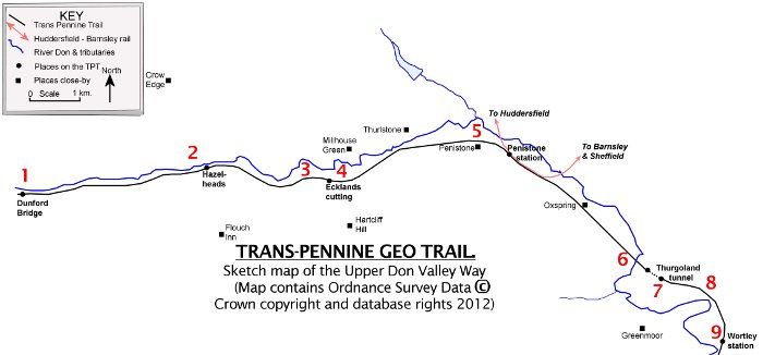
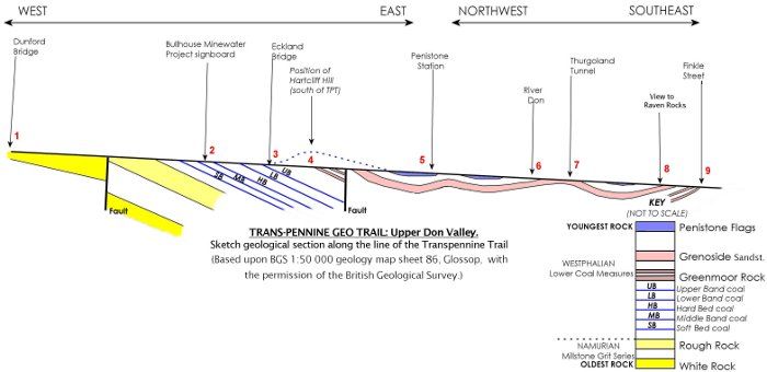
From the car park at Dunford Bridge to Penistone station the TPT runs eastwards along the tributaries of the River Don, in the same direction that the layers of rock are dipping. These rocks are softer, more easily weathered away, mud rocks (often called shales), and more resistant sandstones. The result is that most of the slopes facing you are steeper scarp slopes, whilst those facing the other way are gentler dip slopes influenced by the angle of the gentle easterly dip of the sandstones. From Penistone station the TPT takes a curve to the southeast and runs along the grain, or strike, of the rocks, following the line of the Don Valley. Here the rocks are still dipping eastwards, but they now slope right to left.
The Trail
1. SE159025
2. SE213028
Here you can find the signboard for the Bullhouse Minewater Project. The coal seams formed over 310 million years ago, when England was close to the equator and had a hot, rainy climate. As forests of tall tree ferns, grew, died and fell into stagnant waters, they slowly decayed to carbon-rich seams we now call coal. The sign gives information about how the red mud from the abandoned coal mine workings has been prevented from damaging local streams. The short cutting further to the east is cut through mud rocks and thin sandstones below the Lower Band coal. These rocks have weathered to give soils and a grass covering.
3. SE217026
Dunford Bridge car park lies on Namurian (Millstone Grit) rocks. These sandstones underlie much of the nearby Thurlstone Moors and are responsible for keeping the soils acid and supporting the peat vegetation, along with the high rainfall. These peat areas slow down the flow of rain into the rivers and help prevent flooding downstream in Sheffield. As you travel eastwards you will glimpse small gritstone outcrops. These will be the White Rock sandstone until you cross a fault (not very obvious in the landscape) which drops the Rough Rock sandstone down to the east. These sandstones were formed in large deltas around 320 million years ago as rivers brought sediment from a distant continental area to the north. The Rough Rock is the topmost layer in the Millstone Grit, and further east you move onto younger, Westphalian Coal Measure rocks.
2. SE213028
Here you can find the signboard for the Bullhouse Minewater Project. The coal seams formed over 310 million years ago, when England was close to the equator and had a hot, rainy climate. As forests of tall tree ferns, grew, died and fell into stagnant waters, they slowly decayed to carbon-rich seams we now call coal. The sign gives information about how the red mud from the abandoned coal mine workings has been prevented from damaging local streams. The short cutting further to the east is cut through mud rocks and thin sandstones below the Lower Band coal. These rocks have weathered to give soils and a grass covering.
3. SE217026
A few hundred metres along the TPT is the Ecklands Bridge cutting where the sandstone above the Upper Band coal can be seen. Four metres of sandstone form the steeper slopes and overlie 4 metres of silts and mud rocks. As this layer of rock dips to the east the cutting slowly dies away in that direction.
Ecklands Bridge
4. SE2202
In this grid square there are views south to Hartcliff Hill and the tower. The shape of the hill clearly displays the steeper (scarp) slope facing westwards, and the gentler (dip) slope fading away towards Penistone to the east. The top of the hill, by the tower, is formed by the down faulted, more resistant Grenoside Sandstone, with the thin Greenmoor Rock sandstone layers forming the scarp of Hartcliff Hill. A matching slope can be seen across the valley to the north along High Bank behind the village of Middleton. Where this outcrop crosses the river, ahead, the Don valley becomes narrower where the river has cut through the more resistant sandstone that forms the hills. Here the former railway (TPT) and the Manchester Road follow this easier route created by geological forces, to Penistone.
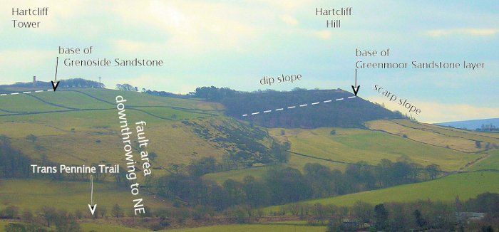
Hartcliffe Hill scarp
5. SE 2403
Penistone has mainly grown up on the slopes above the floodplain of the River Don on the outcrop of the Penistone Flags. Flags are sandstone beds that split into thin slabs. There are three small coal seams amongst the sandstone layers, but they are thin and do not extend very far. The flags were quarried widely for building stones and can be seen on many rooftops in the town. East of Penistone station the river and the TPT make a wide curve to the southeast, so that the beds, which are still dipping eastwards, now dip across the TPT, from your right to your left. You can easily see this just west of Oxspring in the landscape at SE268021. The long gentle slope on your right is the dip slope of the Grenoside Sandstone, whilst the steep valley side to your left is the scarp of the overlying Penistone Flags.
6. SE280009
Here the TPT viaduct crosses the River Don giving great views of the valley. Please take care with children close to the edge. Remember that the valley was once layers of rock that the river has eroded away and taken the sediment downstream to the North Sea. So the next time you are on Spurn Head, say "Hello".
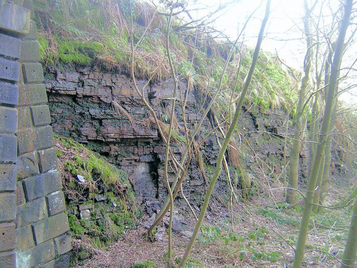
7. SE285005
At the Thurgoland Tunnel cutting the Grenoside Sandstone can be seen forming a large face. This more resistant rock formed the hill that the railway engineers had to cut the tunnel through. On the south side of the tunnel the same sandstone forms a low face on the right (south) with mud rocks lying on top of it. This is because it is dipping eastwards and has gone lower into the ground. On the left hand side (north) of this cutting the higher part of the slope is in the Penistone Flags, above the Grenoside Rock.
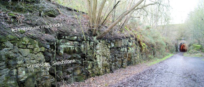
Thurgoland south tunnel entrance
8. SE294002
Ahead and off to your right (south) you can see views of the scarp and dip slope formed by the Grenoside Sandstone at Raven Rocks. It has a well established beech woodland on the steep scarp face and this marks the inside of a meander bend in the River Don where the river has cut a deep valley.
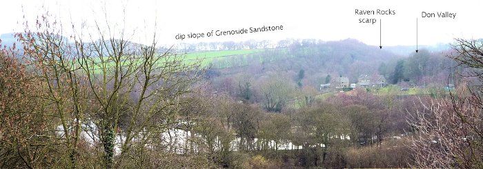
Raven Rocks
9. SK 299993
Finkle Street marks a convenient end to the Barnsley section of the Geology trail. There are many walks across the Don and up to the village of Greenmoor, past Tin Mill Rocher and Forge Rocher to the old sandstone quarries at Greenmoor village, where the Greenmoor Rock sandstone reaches 30 metres in thickness. It indicates that this was the location of a major river channel in Carboniferous times and was so important that the rock was named after the village. In 1813 Reuben Marsh of Penistone leased land near Greenmoor for quarrying, and sub-let to Joseph Brown who was able to cut cobble stones, kerbs and ashlar (stone that could be shaped to a sharp edge). In 1835 he sent stone to London to be used in the Houses of Parliament and stone from here was also used on the steps at County Hall and the Stocksbridge Clock Tower War Memorial.
The TPT isn't just a good walking and riding route: it is also a trip through a landscape where the geology has helped shape the hills, the buildings, the people who lived here and the jobs they did.
