Recording, conserving and promoting the landscape and rocks of the Sheffield region
Woolley Edge Rock
Introduction
In the Westphalian succession in the South Pennine Basin there are almost three dozen significant sandbodies in amongst the shales and coal seams. Superficially they seem very similar: fine to medium grained yellow sandstones; often dune and ripple cross-bedded, all forming similar low scarps facing westwards and gentler dip slopes facing eastwards. However, each has its own character, and its own story to tell. This is what the Woolley Edge Rock can tell us about events around 310 million years ago.
The rocks above and below the Woolley Edge Rock
We know from the plate movement reconstructions that during the Westphalian the South Pennine Basin was part of a waterlogged coastal strip, just north of the equator, on the southern edge of a huge continental mass called Laurussia; to the south was an ocean that would close at the end of the Carboniferous period as the Armorican plate collided from the south. However, the rocks deposited here during the Westphalian are not marine sediments, except for a few rare exceptions. They are dark mudrocks (often called shales) with carbonaceous plant fragments or freshwater bivalves and coals made up of the remains of land plants which were growing in great profusion. Fallen plant debris collected in stagnant swamps and mires where the water table was at the surface. The decay of plant remains used up all of the oxygen in the water, allowing the carbon, and chemically reduced iron, to colour the mudrocks black, instead of oxidising away to carbon dioxide and brown iron hydroxides. Where plant debris was plentiful, peat with woody debris accumulated in the stagnant waters to form coal seams later. The sediments under some coal layers have rootlets, and even plants growing in them that indicate they were well developed soils.
Just below the Woolley Edge Rock is the Meltonfield coal seam indicating that much of the area was a coal swamp with accumulating plant debris. Just above the Woolley Edge Rock is the Newhill coal indicating a return to coal swamp conditions after the period of sand deposition. In between are the Woolley Edge Rock sediments.
All of these Westphalian rocks are clearly deposited in a continental area. The exceptions are the marine shale bands containing bivalves and goniatites, indicating marine flooding events across the low lying swampy coastal plain, but they do not contain corals and crinoids which would indicate clear water, full marine conditions. These marine flooding events were quickly followed by the more usual Westphalian deposits on a low lying, waterlogged coastal area, kept wet by Equatorial rainfall and huge rivers flowing through the region from the vast continental area to the north, west and east.
The Woolley Edge Rock sandbody
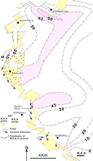
Fig. 1: Sketch map of the Woolley Edge Rock outcrop and the thickness in metres, where buried
The surface outcrop of the Woolley Edge Rock runs southwards for about 30 kilometres from Normanton to just south east of Wombwell. To the west the sandstone has been eroded away, so all the evidence it contained has been lost, probably millions of years ago. To the east the sandstone dips under the surface and it, along with the evidence it contains, would also have been unavailable to us if there had not been a long history of digging coal mines and drilling boreholes through it. Using all the measurements from these shafts and boreholes the BGS could draw thickness contours for the Woolley Edge Rock (See Fig 1). Remember that the total thickness of sandstone in any one place has been built up by channels which repeatedly changed position, and so, thickness alone, does not show where the channel was at any one time. However, this shows us that the maximum thickness is just south of Normanton, and runs in a belt south-south-west to Woolley Edge. Either side of this maximum the thickness reduces to zero within a few kilometres. South east of Wombwell it thins away to nothing, and there is no sandstone outcrop further south - just shales deposited in quiet waters.
Just northwest of Woolley the sandstone also thins to nothing. This makes a cumulative distance from side to side
of about 20 kilometres: i.e. it is a large river system. None of these Westphalian sandstones are simple, uniform layers of rock, so we use the term "sandbody" to describe them. They are interpreted as river flood plain and channel deposits, stacking up one channel sandstone on top of the previous one, in places accumulating over 40 metres thickness, implying that for a period of time in the Westphalian a southwards flowing river deposited sand over a 20 kilometre wide area before it was re-colonised by coal swamps that formed the Newhill coal.
Sedimentary structures in the Woolley Edge Rock
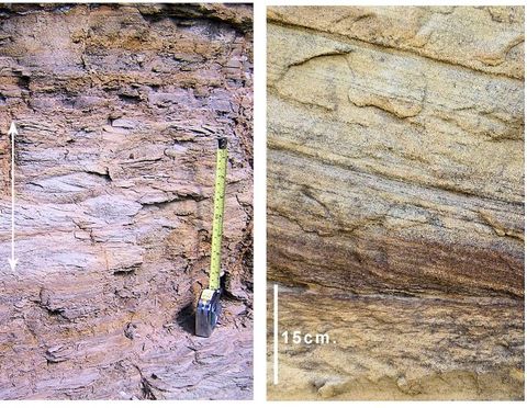
Fig. 2a: Left: Ripple laminated layer (arrowed) between flat laminated layers in Woolley Edge Rock
Fig. 2b: Right: Larger dune sized cross-bedding in Woolley Edge Rock
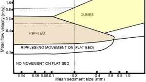
Fig. 3: Graph of ripple and dune development in sand
Many sandbodies, including the Woolley Edge Rock, show large and small-scale cross-bedding which were formed during deposition. From experiments in laboratories (and watching sand on beaches and in rivers) we know that sand grains move when water flows over them. Depending on the speed of flow, and the size of grains, what happens next can vary.
Mostly the Woolley Edge Rock is made up of medium sand which is between 0.25 and 0.5mm in diameter,(with some pebbles in places - more of those later) so, to simplify things, we can assume that what kind of cross-bedding we find is mainly due to changes in the speed of flow of the current that deposited the sand. At low current velocities no sediment moves over the flat sand bed, but any mud is kept in suspension. At slightly higher velocities sand grains roll and small ripples form and move with the flow (but much more slowly than the individual grains. See Fig 2.)
Ripples have short, steep downstream sides which are repeatedly buried as the small ripple moves down-current, and these buried steep faces form the small cross laminations. As the flow increases in speed the ripples re-organise into big ripples that geologists call "dunes". (Not all dunes are formed by wind in deserts, and non-geologists would probably call them sand bars if they saw them in a river). Like ripples they move downstream and continually bury their steep faces to give big cross-beds that can be seen in outcrop. This means that the size of cross-beds in sandbodies can tell us a little about the speed of the flow, and the direction in which they are sloping tells us a little more about the direction of flow. In the Woolley Edge Rock the main direction of flow is generally southwards in our area. (See Fig 1).
The heavy minerals in the Woolley Edge Rock
The Westphalian sandstones are made up of fragments of minerals weathered from rocks in the river catchment, which were then swept downstream and deposited in channels and on a waterlogged floodplain with many lakes. Where the currents were strongest pebbly, or gritty, sand was deposited, and sand filled most of the rest of the channel, with the muds being deposited in lakes and pools on the floodplains. Most of these mineral fragments are quartz, with pieces of feldspar (mostly now weathered to clay) and mica, as well as some clay minerals. A very small percentage are rare, so called, "heavy" minerals. These are infrequent, and very dense mineral fragments (density 3.5 to 4.0 times that of water) that were deposited with the quartz sand grains (density only 2.5 that of water) by the current. Since deposition happens by weight, each of these rare mineral grains weighs about the same as the less dense quartz, which inevitably means they are very much smaller than the quartz grains. Generally they are between 0.063mm and 0.125 mm, rather than the 0.2mm to 2mm for the quartz grains. This means, therefore that these fragments are a similar weight to the quartz grains and are not really "heavy" at all!
These heavy minerals have also been weathered from the rocks in the river catchment, just like the quartz and feldspar, but different source rocks have different combinations of "heavy" minerals. This means a study of the heavy minerals in the sandstones can tell us about the kinds of rocks that were being weathered upstream in the source area. Very simply put: granites produce zircons in the quartz and feldspar sand; medium and higher grade metamorphic rocks produce garnets; chrome spinel indicates that ultrabasic rocks (called ophiolites) were being weathered. Many of these minerals are fairly resistant to chemical breakdown, but they can be lost during transport, or if the rock has been affected by weathering or acidic groundwater after deposition, so interpreting the heavy mineral composition is not as simple as it looks here.
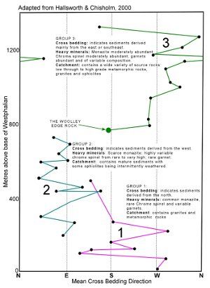
Fig. 4: Graph of Westphalian sandbody characters
(From Hallsworth & Chisholm)
Since all of these Pennine Basin sandbodies were deposited in the same area, one after the other, it is easy to suppose that they will all have the same catchment area and the same group of heavy minerals. They do not. An interesting pattern appears when data is collected about "heavy minerals" and cross-bedding direction from all of these sandstones. There appears to be three separate source areas supplying sands with different heavy minerals into the Pennine Basin. (See Fig. 4)
Early Westphalian sandbodies with cross-beds indicating they were deposited by rivers flowing from the north (but not the Woolley Edge Rock) and contain abundant zircon that indicate the catchment was in granites; they also contain garnets that suggest there were also metamorphic rocks. These are the rocks are exposed when fold mountain belts are deeply eroded.
Slightly younger sandbodies with cross-beds from the west have very few garnets, and a variable, but significant,
chrome spinel combinations of heavy minerals. This suggests catchments of well-weathered mature sediments
(whose heavy minerals have already been destroyed) and an occasional ophiolite exposure are being weathered to supply the sediment.
The youngest sandbodies, (shown as group 3 in green on Fig. 4) starting with the Woolley Edge Rock, have cross-beds suggesting they came mainly from the east. They have an abundant number of garnet fragments of a wide variety of composition, indicating a full range of metamorphic rocks as well as monazite, indicating granites and chrome spinel weathered from ophiolites.
These changes of source material have been interpreted as large scale changes to the river systems caused by the tilting of the crust during the plate collisions as Armorica docked with Laurussia to the north and closing of the ocean to the south. Namurian and Early Westphalian drainage was from the northern continental interior, a deeply eroded fold mountain area with many granites and metamorphosed rocks. Overlapping with this phase of deposition was a time of sand deposition from westwards, an area of mature sedimentary rocks which also intermittently supplied material weathered from ultra-basic igneous rocks, well to the west of Anglesey in what is now eastern USA and Canada. The youngest sandbodies were derived from the rapidly uplifting Variscan mountain chain stretching east to west across what is now Europe. This changed the tilt of the land, and rivers flowed westwards into the Pennine Basin, bringing material from a wide range of igneous, sedimentary and metamorphic rocks in the recently forming fold mountains. The position of the Woolley Edge Rock is a little mysterious. It is the first of the group of sandbodies with a heavy mineral content from the east, but the cross-bedding indicates that the current flow was from the north. The group as a whole has a very wide range of fossil current directions, and may reflect the effects of mountain building to the south, and uplift in the north.
Burton Bank RIGS
Burton Bank Park, in Barnsley, is a good place to view the Woolley Edge Rock. Please remember that it is a protected site, maintained by BMBC. There is a small car park on Newhill Road, accessible from the A633 at Monk Bretton with an access point to the park just to the NW.
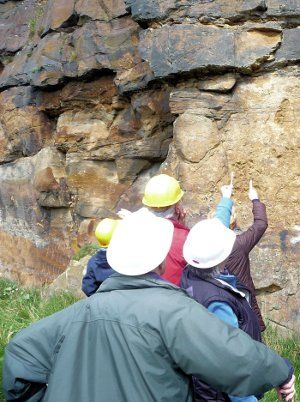
The quarry floor has been back-filled and planted, but the main north-south quarry wall is extensive and shows the main features of a Westphalian channel sandbody. The group in Fig. 5 are inspecting a pebbly layer above an erosion surface in the Woolley Edge Rock.
Fig. 5: Inspecting the Woolley Edge Rock at Burton Bank
Reading
- Hallsworth, C.R. & Chisholm, J.I. (2000). Stratigraphic evolution of provenance characteristics in Westphalian sandstones of the Yorkshire coalfield. Proceedings of the Yorkshire Geological Society, Vol 53 pp43-72
- Mitchell G.H., Stephens J.V., Bromehead C.E.N. & Wray D.A. (1947), (reprinted 1989). Geology of the Country around Barnsley, BGS, HMSO.
- Edwards W. et al (1940). Geology of the Country around Wakefield, BGS, HMSO.
