Silkstone Rock
Recording, conserving and promoting the landscape and rocks of the Sheffield region
Silkstone Rock
The Silkstone Rock is the name for a regional sandstone body forming part of the Coal Measures Group which was originally deposited as sandy sediments by a large river channel during the Middle Carboniferous Period (approx. 312 MY ago). The river flowed across a wide, flat, coastal plain (i.e. varying from floodplain to shallow lakes to river delta to estuary) in the area where Sheffield and other parts of South Yorkshire exist.
Continued deposition of more Coal Measures sediments resulted in the progressive burial of the river channel sands beneath younger strata. Increased pressure and mineralogical changes associated with deep burial caused the sandy layer to become cemented into hard rock. Subsequent earth movements and regional uplift have caused local deformation of the Coal Measures (i.e. gentle folding and faulting) as well as tilting of the strata away from the Pennine hills towards the east. This has resulted in the erosion and removal of the Silkstone Rock everywhere west of Sheffield, while further to the east it is preserved at depth beneath younger strata. The outcrop of the Silkstone Rock is where it is revealed in cross-section at today's ground surface.
As a result of the regional easterly dip (common to all Carboniferous and younger strata), the Silkstone Rock outcrop is orientated generally south-to-north. Also, because it is harder and more resistant to erosion than the silty and shaly rocks above and below it, it forms a series of prominent and well-known landscape features throughout Sheffield and some adjacent districts.
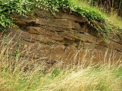
The palaeo-river which deposited the sandy channel sediments that now form the Silkstone Rock flowed eastwards across the south Yorkshire area towards a shallow, continental sea - probably located where the North Sea is today. The river channel stayed in the same position for a long period of time and accumulated a considerable thickness of sand (the maximum thickness of Silkstone Rock exceeds 50 m). Clear outcrops of the rock unit are not very common, but those exposures which can be seen show some of its complex, "multi-story", internal structure.
The Silkstone Rock was deposited after, and on top of, a major regional coal seam (i.e. the Silkstone Seam). Two other coal seams (the Three-quarters and the Low Thorncliffe) developed on the marginal floodplain contemporaneously with the river, as demonstrated by the manner in which they degrade and pinch-out as the thick channel sandstone body is approached.
The shape of today's outcrop of Silkstone Rock is the result of the combined effects of four major features, events or processes, i.e. the varying thickness of the sandstone unit, the regional tilt, local deformation by folding and faulting and finally the modern landscape surface sculpted by recent erosion and river drainage.
Very helpfully, information about the thickness and character of the concealed extensions of the Silkstone Rock to the east of Sheffield is known from geological observations from numerous colliery shafts and from exploration boreholes for coal, oil and gas. These data, in combination with evidence from rock outcrops, show that the principal river channel flowed from a westerly source, through Dronfield, continuing in the direction of Killamarsh, Worksop, Retford and beyond. The river deposited a sinuous ribbon of sand, 5-10 km wide, for a distance of at least 45 km between today's eroded western edge and the eastern-most borehole to have intersected it (located between Gainsborough and Lincoln). The thickest accumulation of sandstone was deposited in the centre of the channel.
A second river channel may have flowed in a south-easterly direction (possibly from the Huddersfield area) and joined the principal channel around Dronfield. It may have flowed in a meander around Sheffield, creating separate area of thick sandstone accumulation which is not quite so ribbon-like in form.
Tour of the Silkstone Rock outcrop from south to north
New Paragraph
Indian restaurant car park, Sheffield Road, Dronfield (October 2012)
Snape Hill, Dronfield (October 2012)
The Silkstone Rock 'ridgeway' near Highlane
(September 2013)
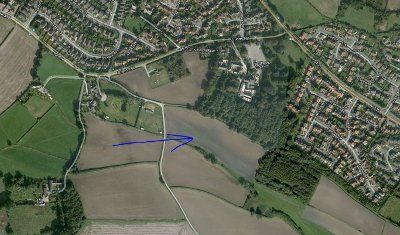
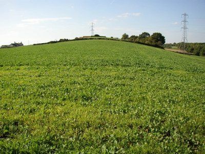
Field line between Highland and Mosborough
(Google Earth Image)
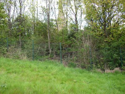
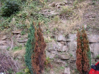
G96 Cholera Monument, Clay Wood
(May 2012)
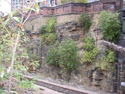
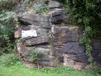
G172 Gilbert Street Railway cutting
(August 2011)
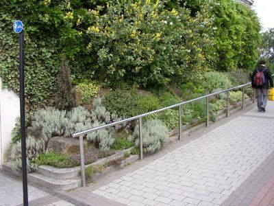
Ramp near Central Library
(June 2012)
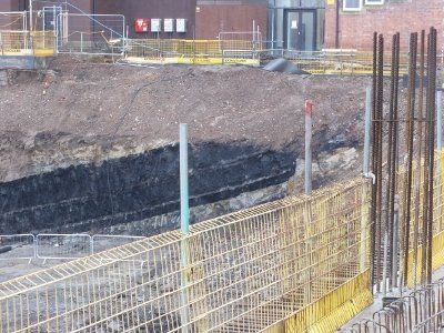
Excavation for the foundations of the University of Sheffield's new engineering block on the site of the old Jessop Hospital revealed the Silkstone coal seam. (January 2014)
The rocks now lie beneath the University's Diamond Building
Scotland Street (June 2012)
Pye Bank Road exposure (August 2012)
The extensive outcrop of Silkstone Rock surrounding Dronfield has been gently folded into an elongated, 'trough' shape by the shallow syncline on which the village is situated. The edge of the outcrop forms a bank (a low 'rampart') which encloses Dronfield Woodhouse on three sides, before extending eastwards to form an escarpment at Holmley Common, Coal Aston and Troway.
There are no clear exposures of Silkstone Rock along the outcrop edge, but some good exposures can be seen in Dronfield, in excavations behind a few of the buildings along the east side of Sheffield Road and Chesterfield Road (B6057). Cross-bedding structures can also be seen in a roadside outcrop near the junction of Snape Hill with Sheffield Road. At this outcrop an average azimuth of N96ºE can be measured from the inclined faces of the cross bedding. This is evidence to support the interpretation that the Silkstone Rock was deposited by an easterly flowing palaeo-river in this area.
Around Mosborough, the Silkstone Rock is folded again by the Norton-Ridgeway Anticline, which turns the outcrop orientation to a north-westerly direction. The outcrop edge forms the prominent high ground (the 'ridgeway') from Mosborough, past Highlane to Whitelane End. Unfortunately, no rock exposures can be seen here.
The Silkstone coal has been extensively worked along its outtcrop beneath the Silkstone Rock in previous centuries, but there is little evidence of this historical working to be seen today. A minor exception, however, is the dark line which can been seen crossing fields in freshly-ploughed autumn soil between Highlane and Mosborough (or on Google Earth imagery).
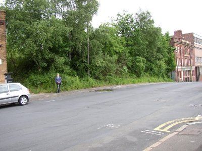
On the north-northwest side of Whiteland End the Silkstone Rock forms the high ground beneath Gleadless, Arbourthorne and the eastern side of Norfolk Park, after which it crosses beneath Norfolk Park Road to form the ground on which the Cholera Monument was built. Clay Wood, next to the monument, is the site of some historic ironstone workings beneath the Silkstone Rock (Sheffield site G99), but these remains are now extensively overgrown and no outcrops can be seen at the present time. A small outcrop of Silkstone Rock occurs beneath the monument (Sheffield site G96), but this is also currently obscured by dense vegetation.
Northwest of the Cholera Monument site, the Silkstone Rock descends into the Sheaf Valley in Sheffield, where it is hidden behind the high grassy bank situated between the Park Hill flats and Sheffield Railway Station. The flats are probably built on top of the Silkstone Rock.
A good overview of Sheffield city centre can be seen from the top of the steps leading down the grassy bank, near the junction of Shrewsbury Road and Talbot Street. On the opposite side of the railway station the Silkstone Rock outcrop ascends up the west side of the Sheaf valley where it forms the steep hill on which Sheffield Hallam University has been built.
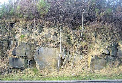
Sheffield Station and the Park Hill flats are located in an area where the Silkstone Rock is present as a very thick, massive sandstone, through which a deep railway cutting has been excavated on the north side of the station. A cross-section through the sandstone is visible on the eastern side of the cutting. These rock exposures are not accessible to the general public, but parts can be glimpsed from over the top of the parapets of two pedestrian bridges crossing the railway at Gilbert Street (Sheffield site G172). Here, the sandstone bedding planes can be seen to dip at a gentle angle to the northeast (being located on the southern limb of the shallow, easterly-plunging syncline).
The general thickness of the Silkstone Rock in this area is known from several nearby wells, boreholes and coal-mine shafts. The Exchange Brewery well, located near Ladies Bridge and dug in the 1890s, was begun in Silkstone Rock at the ground surface and its base was reached at a depth of 90 ft (≈27m). Similar thicknesses were intersected at Manor Castle colliery (Manor Lodge) and at Nunnery East colliery (just slightly east of Woodburn Road).
Like Dronfield, Sheffield is located on an eroded, gentle synclinal fold. The Silkstone Rock outcrop forms a high platform with a shallow trough-like shape on which much of the city centre has been constructed. Very few exposures of Silkstone Rock are visible today within the city centre. One possible small exposure, in the vicinity of Sheffield Hallam University, is located next to the pavement ramp which connects the lower entrance to the Millennium Gallery with Sheffield City Library (Sheffield site G374). Partly hidden by ornamental shrubbery, the rocks here appear to be disturbed and they may not be in their original positions.
The edge of the Silkstone Rock extends in a westerly direction from Howard Street to Furnival Gate and the roundabout at Charter Square. The Town Hall, Peace Gardens, Library, Art Gallery etc were all built on the Silkstone Rock. Occasional old coal mine shafts have been discovered in this area during building works, and other unknown shafts probably exist. The shafts were sunk through the sandstone to gain access to the Silkstone coal seam beneath.
The Sheffield Fault (trending NW-SE) dislocates the Silkstone Rock on the west side of the city centre, and its exact position is not known, although it is likely to underlie the area between Devonshire Green and St. George's Church, where the fold axis turns the outcrop back to a north-east direction again.
The north-western limb of the syncline forms the prominent, northeasterly-trending ridge adjacent to Broad Lane. A single outcrop of rock, now much overgrown, can be seen at the junction of Scotland Street and Furnace Hill.
The outcrop area of the Silkstone Rock continues in an east-northeast direction from Scotland Street towards the River Don, where it forms the gently sloping ground beneath the Law Courts, Corporation Street, Bridgehouses Roundabout (on Derek Dooley Way) and parts of Kelham Island. The Silkstone Rock did not form an obstacle to the River Don, which has eroded a channel through and across it. On the northeast side of the Don River Valley the Silkstone Rock becomes noticeable again where it forms the distinctive ridge of higher ground in Burngreave, on the summit of which is located the Nottingham Street Recreation Ground. Further down the slope, closer to the river, a small exposure of Silkstone Rock can be seen next to the roadside near the junction of Pye Bank Road and Rock Street.
On the northeast side of Burngreave Road the ridge of high ground formed by the outcrop of the Silkstone Rock continues beneath Burngreave Cemetery (Pitsmoor) towards Grimesthorpe, where a colliery was opened in the 1890s to mine the Silkstone Coal seam. This northeasterly-trending ridge of Silkstone Rock (which dips in a south-easterly direction) is a visible surface expression of a regional fold structure called the "Don Monocline". This fold structure has also influenced the course of the River Don, which here flows parallel to the fold axis.
Beyond Grimesthorpe, the outcrop of the Silkstone Rock forms the high ridge through Wincobank towards Junction 34 of the M1 motorway, near Meadowhall.
On the northeast side of the M1 the Silkstone Rock forms the high ground beneath the Richmond Park and Dropping Well area of Rotherham. The archeologically important remains of bell pits for working ironstone are still visible in fields adjacent to Little Common Lane (Rotherham site R481), and Dropping Well Colliery was located in the Old Hall Sport Centre ground, opposite Winterhill School.
The Silkstone Rock in the Dropping Well area is located on fold axis of the Don Monocline and the outcrop turns here from a north-easterly to a north-westerly direction. The rock was quarried from Dropping Well during the 19th and 20th centuries. Exposures can be seen there today. (Rotherham site R100).
A short distance northwest of Dropping Well, the Silkstone Rock outcrop forms the broad expanse of high ground at Grange Park and an exposure of rock can be seen at Walkworth Wood scarp (Rotherham site R131).
From Grange Park the outcrop of the Silkstone Rock follows a continuous north-westerly trend, but the sandstone becomes thinner, less massive and is inter-bedded with thin beds of siltstone and shale. Consequently, it does not form such distinctive landforms as those seen in the Sheffield area. The M1 motorway crosses the Silkstone Rock outcrop again just south of Junction 35 (Thorpe Common).
From Junction 35 the Silkstone Rock outcrop forms the low ground underlying the eastern side of Chapeltown, beyond which it can be traced into Wortley Park, where it is present beneath the higher ground on both sides of High Wood Dike (Buck Park and Lane Royds Park).
From Wortley Park the Silkstone Rock outcrop can be traced past Crane Moor (and the nearby Vernon Silkstone and Cliffe Bridge Collieries) to Bagger Wood and adjacent ground to the west. From there it forms the top of the escarpment of Tom Royd Wood, then it extends to Berry Moor - Dodworth Moor before sweeping around the west side of the village of Silkstone Common. The Dove Valley Trail (part of the Trans-Pennine Trail system), created along a disused railway line, crosses the outcrop of the Silkstone Rock, some of which is exposed in the Nabs House Cutting (Barnsley site B44).
B156 Silkstone bypass(June 2012)
B8 Bentcliffe Hall Quarry
Across Silkstone Beck The Silkstone Rock forms the ground beneath Noblethorpe Park.
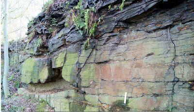
A fault displaces the outcrop eastwards - creating good exposure in a road cutting along the A628 (Silkstone by-pass) (Barnsley site B156).
The Silkstone Rock outcrop underlies part of the eponymous village of Silkstone, then the higher ground of Banks Hall on the north side of Banks Bottom Dike, where it is exposed in the disused Bentcliff Hall quarry etc. (Barnsley site B8).
From there the outcrop can be traced downhill along the escarpment edge into Cawthorne, where another good exposure can be seen in the disused Hill House quarry (Barnsley site B167).
North of Cawthorne the outcrop of the Silkstone Rock forms the upper slope of the south-facing valley side overlooking the "Cascade" and Cawthorne Dike in Cannon Hall Country Park.
