Recording, conserving and promoting the landscape and rocks of the Sheffield region
Greenmoor - Brincliffe Edge Rock
After becoming the first landowners in Barnsley MBC to have a Geological Action Plan for their RIGS site, Hunshelf Parish Council asked SAGT to present a talk entitled "The Great Hunshelf River", the local nickname given to the inferred flow which deposited the Greenmoor Rock. The talk drew on evidence from a wide variety of places to describe a general outline of the landscape, vegetation and ecology of Hunshelf during the very early Westphalian.
This page is a summary of that talk. It deals with some of what we know about Westphalian river catchments, and some of the evidence for it.
All photos and diagrams by R. Ramsdale, except where otherwise stated.
1. INTRODUCTION
By the Late Carboniferous Earth had a large south polar icecap, which affected sea levels, and the British Isles lay close to the equator on the southern margin of a huge continent called Laurussia. To the north was a deeply eroded mountain range with large rivers draining from it. To the south plate tectonics was uplifting an east-west Variscan fold mountain range, forming to the north a series of interconnected, periodically downfaulting, sea-level basins which ran for over 2000 kilometres from the eastern USA (which at that time was next to Europe), through Barnsley, to the Ukraine. These basins became infilled by the sediments washed in from the northern uplands forming the "Millstone Grit Deltas". Later, on top of these deltas, the Westphalian rivers started to build deltas into the large series of basins until they created a sea level coal forest swamp area with equatorial plants and animals quickly colonizing the surface. Here a vast and unique ecosystem developed for around 4 million years before being destroyed by the collision of Gondwana from the south to uplift a huge continent called Pangaea, about 300 million years ago. The "Great Hunshelf River" catchment basin was part of this, now destroyed, landscape.
2. WESTPHALIAN CATCHMENTS AND THE FIELD EVIDENCE
2a) The Big Picture
It is no surprise that a large sea level swamp area should become the focus of continent size drainage systems, but in the case of the Pennine Basin the prolonged continental collisions seems to have caused continental tilting and major changes in river direction. This was demonstrated in work published in 2000 which mapped every major sandstone in the East Pennine Basin according to, first, its direction of palaeo-current, and second, according to the mineral content. This gave information of the kinds of catchment basins being eroded far upstream.
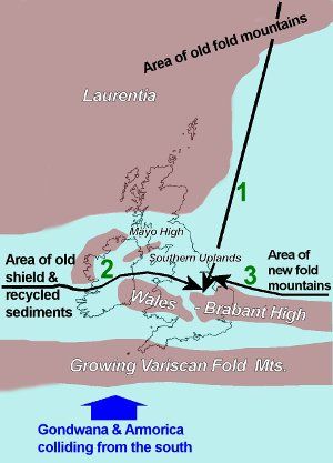
Fig. 1: Westphalian Sediment Trains
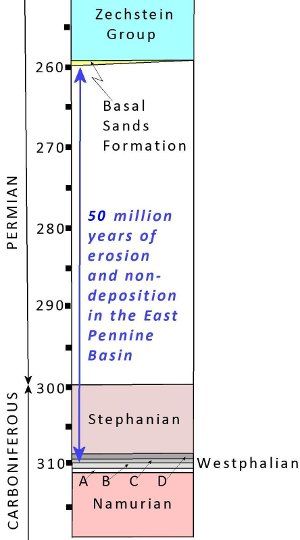
Fig. 2: Time Column - Millions of years ago (Mya)
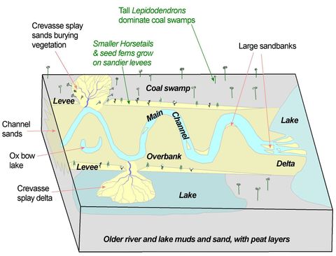
Fig. 3: Sketch of a Westphalian lower catchment landscape
Three different upstream areas have been identified as the source of the sediment trains for the Westphalian sandstones. These areas must have been clothed in equatorial vegetation, and received large amounts of rainfall, but because they are erosional areas, no direct evidence remains of them. The earliest Westphalian source was from the north where an old mountain range was still being deeply eroded. The second one overlapped in time with the first by bringing sediment from the west, from deep into what is now the USA/Canada. This was an area of old and stable continental interior where mature sediments had been eroded and deposited many, many times, destroying less resistant minerals. The "Great Hunshelf River" deposited the first sand from this westerly region to form the Greenmoor Rock. Immediately over this sandstone lie shales, followed by the Grenoside Sandstone, part of the northern derived sediments overlapping with the western ones. Later the Woolley Edge Rock became the first of the third group of rivers which flowed mainly from the east, along the newly formed fold mountains to the south caused by the collision from the south of Gondwana.
All of the late Westphalian (and any younger Stephanian) rocks that were deposited here have been destroyed by uplift and erosion before the Permian rocks were deposited on top, around 260 million years ago. Even so, about 1.4 km thickness of earlier Westphalian sediments and evidence remain for us to examine. (See Fig. 2)
2b) Westphalian lower catchment landscapes
We know most about the lower catchment basins of these rivers, because that is where the evidence became buried, preserved and later exposed by quarries and mines. Unfortunately much of the geological evidence has now been reburied by humans, landscaped, or built on, especially in the Greenmoor sandstone quarries, so this story draws on evidence from similar Westphalian sandstones in the East Pennine Basin, as well as borehole and old mine records, and exposures further afield. We know the main channels of these Westphalian rivers were very large and meandering, infilling linked basins between the upland blocks of the Wales-Brabant, Ireland and Scottish Uplands. They carried vast amounts of mud and sand into the basin to form deltas. In the early Westphalian these were often flooded by sea level rises caused by the ice cap in the southern hemisphere. Sands formed much of the channel floor and adjacent overbank areas. Although the channels frequently flooded, due to changes in flow amounts, they were mostly confined between natural banks called levees, so they tended not to meander all over the basin, but built up thick channel deposits along one line over many thousands of years. The overbank flood deposits added thinner sandstones along the edges.(See Fig. 3)
Outside of the levees the deposits tended to be, either lake deposits of silt and mud, or "coal forest swamp" deposits where vast areas of tree-like vegetation (Lycopods, called Lepidodendron) grew and reproduced in waterlogged and flooded conditions. Their outer cortex and branches, and eventually whole trunks collapsed to form peat. This plant debris did not decay in the stagnant waters of the coal swamp, but accumulated as the carbon rich, organic deposit we call coal.
There is also evidence to suggest that the main rivers had flood pulses of water and sediment, occasionally breaking through and inundating the overbank areas. This process buried riverside plants by laying down sand layers called "crevasse splay deposits", or built "crevasse splay" deltas into the lakes.
2c) The Evidence
More information on Westphalian Plants
(i) Channel size and shape.
This depositional pattern means the shapes of these sandstones are not simple layers, they have thick channel sections, and thinner overbank sections which sometimes split into two by shale layers; so, instead of calling them "beds" they are often called sand bodies. The Greenmoor "channel-sandstone" width is only a few kilometres, and east of Barnsley, the width of the whole Woolley Edge sand body is 20 km. The direction of flow of the river is found by measuring the direction of the sloping cross beds. These are the buried downstream faces of large "sand bars" in the river. The ones in Fig. 4 are in the Wharncliffe Rock and show the current was flowing left to right. This sand bar was at least 8 m high, indicating that the river was deep and powerful.
ii) Overbank: lakes and swamps.
The evidence for large sheets of shallower, often standing, water, comes from bedding planes with symmetrical ripples, created by wind over water. Often asymmetrical ripples occur between flat bedded lake deposits, indicating the pulses of water moving through them. Sometimes these beds have thicker sandstones with cross-bedding, indicating a sudden influx of water and sand. These are interpreted as "crevasse splay" deposits. Fig. 5 shows an example from the Woolley Edge Rock. Sandstone "B" tapers to nothing on the right, where the crevasse splay current ran out of energy, and another example of "crevasse splay" sandstone from Brymbo, in North Wales, where Calamites
stems have been buried by a cross-bedded sandstone, when the channel flow broke through the levee and buried the plants.
(iii) Plants growing in the catchment basins.
Calamites
(horsetails) grew around the edges of shallow lakes on the floodplain. On drier levees, and areas with sandy soil, larger Sigillaria
"trees" grew, with an under-canopy of smaller Seed Ferns and Tree Ferns. In the flooded swamp areas it was the tall Lepidodendron
species that dominated in an environment too wet for other plants. They could survive in water up to 2 m deep, and lived maybe 30 years. They grew rapidly to 30 m, sprouted branches at the top with cones containing the spores, which in some species probably became fertilised in the waters below (Lycopods need water to reproduce). As the plants grew the thick woody outer cortex split off and dropped into the stagnant water to form a large component of the peat, which later became a coal seam. Little is known about the upland parts of the catchment away from the water, because these were erosional and very few deposits have survived, but it is possible that early gymnosperms (coniferous plants) had adapted to colonise these slightly drier upland areas.
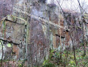
Fig. 4: Large cross beds in Wharncliffe Rock
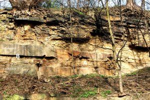
Fig. 5a: Crevasse splay sand layer in Woolley Edge Rock
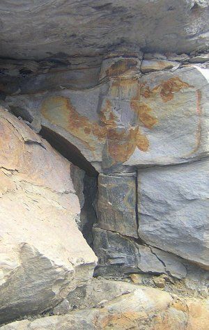
Fig. 5b: Calamites trunk buried by crevasse splay sands. Brymbo North Wales.
(iv) Westphalian catchment basin animal ecosystems.
The fossil evidence for the animals colonizing these ecosystems is very rare in the East Pennine Basin because acid groundwater and oxidizing weathering conditions have destroyed much of it. There are very few fossils in the sediments deposited by the "Great Hunshelf River". In most cases not even an imprint is left. This means the evidence has to come from further afield. The most complete indicator of what was living in the Westphalian catchments comes from Mazon Creek, an old strip coal mine in Illinois, USA. The fossils here are exceptionally well preserved in nodules of siderite (iron carbonate) and are so plentiful they give the most complete picture of what Westphalian ecosystems might have looked like 306 Mya. (These fossils are about 6 million years younger than the Greenmoor Rock.)
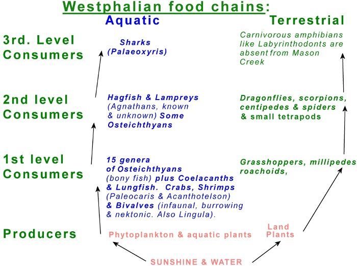
Fig. 6: A possible Westphalian ecological structure based on the Mazon Creek fauna
In addition, an oxygen rich/CO2
poor atmosphere is more dense, and allows flying organisms, like dragonflies, to fly more easily at larger sizes. Meganeura
is a Westphalian fossil dragonfly (from China) with a wingspan over 80 cm.
(v) Fossil evidence from the East Pennine Basin
In the last few years there have been remarkable finds of rare, fossiliferous siderite nodules on old pit tips, usually just before they were buried and landscaped. Rabbit Ings, in Barnsley, provided plentiful numbers of fossiliferous siderite nodules before being top-soiled and planted up. In two of these nodules examples of shark egg cases (Paleoxarys) were discovered. On a pit tip near Doncaster, several finds have been made, including Paleoxarys
and Euproops, a Horshoe Crab, demonstrating similarities with the Mazon Creek ecosystem (see Figs. 6 &7).
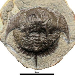
Fig. 7a: Euproops - Horseshoe Crab
(Doncaster Museum. Photo Dean Lomax)
Slightly more common in the East Pennine Basin are bivalve traces and fossils. Infrequent, but very fossiliferous, layers called "Mussel bands" are known, and are usually full of crushed shells in a siderite matrix. Sometimes the siderite formed quickly after burial, and prevented the shells from being crushed by the overlying weight of sediments. These are often formed where shellfish have been stranded, or washed around after death and deposited together. Lockeia
is a trace fossil of bivalves which lived in the top of the sandy sediment and eased themselves higher as the sediment built up around them to keep their inhalant and exhalent siphons clear of the sand and mud. This left a trace behind in the thickening bed of sandstone that often looks like a near-vertical burrow. (See Fig. 8)
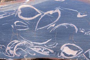
Fig. 8a: Mussel Band
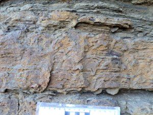
Fig. 8b: Lockeia
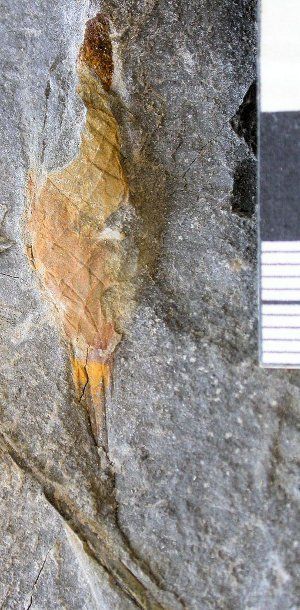
Fig. 7b: Paleoxarys - A shark egg case
(Doncaster Museum. Photo Dean Lomax)
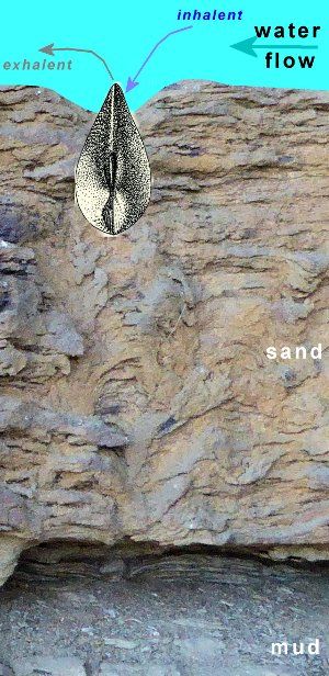
Fig. 8c: Lockeia reconstruction
3. THE GREENMOOR/BRINCLIFFE EDGE ROCK AT OUTCROP
The inferred river flow that deposited the Greenmoor Sandbody, has been informally given the local nickname "The Great Hunshelf River". Today the outcrop of the Greenmoor Rock curves south-eastwards from Penistone to Greenmoor and Oughtibridge, and then more southerly through the western suburbs of Sheffield, where it is known as the Brincliffe Edge Rock. There are very few economic coal seams close below the Greenmoor Rock, so we have very few underground points of information from boreholes and mine shafts away to the east of the outcrop, where it lies buried. To the west, the whole of the Greenmoor Rock has already been eroded away, leaving only a thin ribbon of outcrop evidence to examine at the surface today. Over most of its length the sandstone is thin, and often in two or more layers, suggesting it formed as overbank deposits. Only at Greenmoor and Brincliffe does the layer thicken up to around 30 metres, hinting at the presence of a channel. (See Figs. 9 & 10)
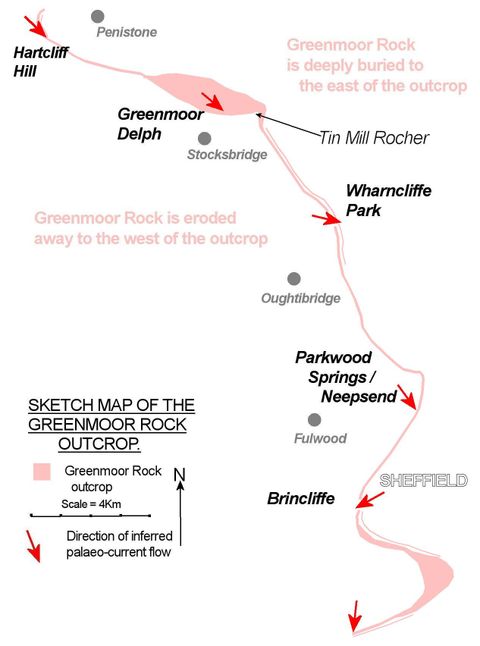
Fig. 9: Sketch Map of the Greenmoor Rock Outcrop
The oldest part of any sedimentary layer is the bottom, which was deposited first, but the base of the Greenmoor
Rock is not clearly exposed in many places. At Parkwood Springs the base of the sandstone lies on top of shales and is made of fine silts, becoming sandier upwards. The sedimentary structures in the beds suggest this part was a delta building out into a large lake. Above, there are two more delta layers, suggesting the delta was drowned and re-built three times in all. (See Fig. 10a). At Tin Mill Rocher the base of the same sandstone is different. Here, the beds are made up of small scale ripple structures in flat beds, suggesting, not a delta, but initial spreads of sand deposited from slower moving sheets of water, building up the sandy layers, perhaps alongside the main channel. The most promising site for the thick channel sandstones of our so-called "Great Hunshelf River" is at Greenmoor, and is about 5 km across. However all of the deep quarries in the area are now backfilled, and some are built on, so this means we have to rely on old records and photographs from the heyday of quarrying. (See Fig. 10b). These do hint at thick beds with large cross-beds about 10 metres or so below the surface, passing upwards into the more thinly bedded layers with ripples and occasional cross beds seen at the Greenmoor Delph RIGS site (Fig.10c).
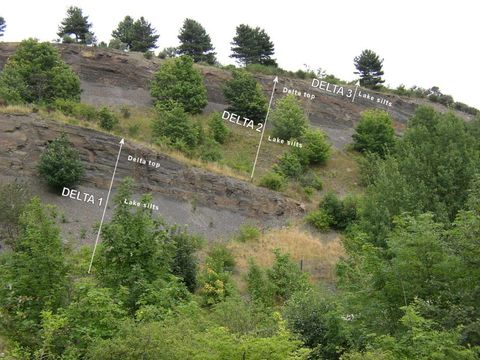
Fig. 10a: Greenmoor Sandstone Delta deposits at Parkwood Springs (Photo John Hunter)
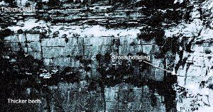
Fig. 10b: Early photograph of 60 Steps Quarry, Greenmoor (Thanks to David Horsfall)
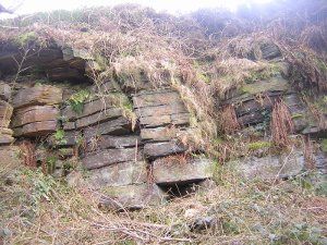
Fig. 10c: Greenmoor Delph RIGS site
The end of the river system is signalled at the top of the sandbody, where sand layers with symmetrical ripples on top (Fig.11a), pass up into thin shales, suggesting a shallow lake, slowly silting up. Slumping of sand layers, probably along the sides of channels, or sloping fronts of sandbars, can be seen quite frequently in outcrop (Fig.11b), suggesting that strong currents were no longer flowing. Rootlet beds (Fig 11c) show that the sediment was now stable enough to support plant growth, and the fine-grained, overlying shale indicate that currents became very weak. These shales are black, with coaly fragments, indicating quiet conditions where waterlogged vegetation sank and was buried in the stagnant waters which had replaced the river deposits. Later sediments then buried these beds completely, until erosion revealed them again millions of years later.
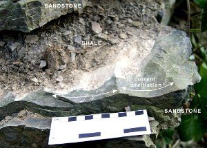
Fig. 11a: Symmetrical ripples at the top of Greenmoor sandstone
(Photo Peter Kennett)
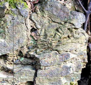
Fig. 11b: Slumped sand layers at the top of the Greenmoor Rock
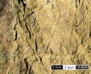
Fig. 11c: Rootlet bed at the top of the Greenmoor sandstone
It is possible that an even larger main channel lay west of the present outcrop, and has now been eroded away, leaving no evidence of its presence: if so, only the fragments of the eastern side of its overbank sediments and tributaries remain. These were deposited in lakes and sandflats by currents meandering roughly southwards across a sandy floodplain. It may be that the "Great Hunshelf River" at Greenmoor, sizeable though it was, was only part of a very much larger river system: perhaps the "Really Humungous Hunshelf River"?
